1960s Maps of Omaha, Texas
Explore 2 historic maps of Omaha from the 1960s. These maps offer a rare glimpse into what life looked like during the 1960s — showing old roads, neighborhoods, homes, and landmarks that have changed or disappeared over time.
Whether you're researching your family's past, planning a metal detecting trip, or studying how Omaha's landscape evolved across the 1960s, these high-resolution maps are a powerful tool for exploring the history of this region.
- Focus on a specific era: All maps on this page are from the 1960s, giving you a focused view of this time period.
- See what’s changed: Compare century-old streets, trails, and buildings to today's modern landscape using overlays and satellite layers.
- Research with precision: Use these maps for genealogy, historical research, land use analysis, or educational projects.
- View, download, or print: Maps are fully viewable online in high resolution, and can be downloaded or printed for your own records.
Start exploring Omaha's history through authentic maps from the 1960s. This is your window into the past.
Omaha, TX maps
(2)- 1965 Map of Naples, 1967 Print
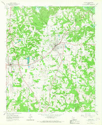 1965 Naples1967 Print · USGSNortheast Texas in the mid-sixties reveals a landscape defined by the railroad and established country communities. Genealogists and historians can trace the foundations of Naples and Omaha, locating local landmarks like Pewitt Sch and Spring Hill Cem.2 unique versions available
 - 1965 Map of Cookville, 1968 Print
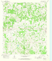 1965 Cookville1968 Print · USGSMid-century East Texas comes into focus along the St Louis Southwestern rail line between Cookville and Omaha. Genealogists and local historians can trace family roots through numerous sites like Mt Moriah Ch, Concord Cem, and Center Grove.2 unique versions available
End of results
Showing maps 1-2 of 2
Top cities near Omaha
- Mount Pleasant historical maps
- Pittsburg historical maps
- Daingerfield historical maps
- Hughes Springs historical maps
- Naples historical maps
- Marietta historical maps
Frequently asked questions
- What are the different types of historical maps available for Omaha?
- What is the oldest map of Omaha?
- Where can I purchase historical maps of Omaha for my home or office?
- Where can I download high-res historical maps of Omaha?
- Are there historical topographic maps available for Omaha?
- Is there historical aerial imagery available for Omaha?
- Where are historical maps of Omaha sourced from?