1940s Maps of South Toledo Bend, Texas
Explore 2 historic maps of South Toledo Bend from the 1940s. These maps offer a rare glimpse into what life looked like during the 1940s — showing old roads, neighborhoods, homes, and landmarks that have changed or disappeared over time.
Whether you're researching your family's past, planning a metal detecting trip, or studying how South Toledo Bend's landscape evolved across the 1940s, these high-resolution maps are a powerful tool for exploring the history of this region.
- Focus on a specific era: All maps on this page are from the 1940s, giving you a focused view of this time period.
- See what’s changed: Compare century-old streets, trails, and buildings to today's modern landscape using overlays and satellite layers.
- Research with precision: Use these maps for genealogy, historical research, land use analysis, or educational projects.
- View, download, or print: Maps are fully viewable online in high resolution, and can be downloaded or printed for your own records.
Start exploring South Toledo Bend's history through authentic maps from the 1940s. This is your window into the past.
South Toledo Bend, TX maps
(2)- 1944 Map of Wiergate
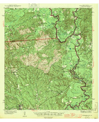 1944 Wiergate1944 Print · USGSNewton County and the Sabine River borderlands are captured here in the mid-1940s during the peak of the local timber era. Genealogists and researchers can trace family landmarks like Toledo Cem, the Gulf Northern rail line, and the rural Mayflower Sch.2 unique versions available
 - 1948 Map of Wiergate, 1954 Print
 1948 Wiergate1954 Print · USGSThe Sabine River bottomlands and the timbered hills of Newton County are mapped here in the late 1940s. Genealogists and historians can trace rural life through landmarks like Anthonys Ferry, Scott Cem, and the old Sycamore Sch in the heart of the Sabine National Forest.
End of results
Showing maps 1-2 of 2
Top cities near South Toledo Bend
Frequently asked questions
- What are the different types of historical maps available for South Toledo Bend?
- What is the oldest map of South Toledo Bend?
- Where can I purchase historical maps of South Toledo Bend for my home or office?
- Where can I download high-res historical maps of South Toledo Bend?
- Are there historical topographic maps available for South Toledo Bend?
- Is there historical aerial imagery available for South Toledo Bend?
- Where are historical maps of South Toledo Bend sourced from?