1920s Maps of Orange County, Texas
Explore 5 historic maps of Orange County from the 1920s. These maps offer a rare glimpse into what life looked like during the 1920s — showing old roads, neighborhoods, homes, and landmarks that have changed or disappeared over time.
Whether you're researching your family's past, planning a metal detecting trip, or studying how Orange County's landscape evolved across the 1920s, these high-resolution maps are a powerful tool for exploring the history of this region.
- Focus on a specific era: All maps on this page are from the 1920s, giving you a focused view of this time period.
- See what’s changed: Compare century-old streets, trails, and buildings to today's modern landscape using overlays and satellite layers.
- Research with precision: Use these maps for genealogy, historical research, land use analysis, or educational projects.
- View, download, or print: Maps are fully viewable online in high resolution, and can be downloaded or printed for your own records.
Start exploring Orange County's history through authentic maps from the 1920s. This is your window into the past.
Orange County, TX maps
(5)- 1926 Map of Terry
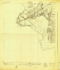
 1926 Terry1926 Print · USGSCoastal Orange County was a hub of energy and rail transit in the mid-twenties, centered on the Neches River wetlands. Researchers can trace early infrastructure like the Southern Pacific tracks and the Mansfield Gulf Ferry Road.
 - 1926 Map of Lakeview
 1926 Lakeview1926 Print · USGSThe Neches River lowlands are captured here in the mid-1920s, showing a landscape defined by marshy sloughs and emerging industry. Genealogists and historians can locate family landmarks like the Williamson Church or trace old routes to Colliers Ferry.
 - 1926 Map of Vidor
 1926 Vidor1926 Print · USGSThe Neches River basin in the mid-1920s shows a landscape of winding waterways and emerging rail corridors. Researchers can trace the early footprint of Vidor and find rural landmarks like the Magnolia Grove School alongside the Kansas City Southern line.
 - 1926 Map of Texla
 1926 Texla1926 Print · USGSCoastal Texas in the mid-1920s is defined by its winding waterways and expanding rail lines. Genealogists and industrial historians can trace the Kansas City Southern route past the Linscomb Cem and the settlement at Texla.
 - 1926 Map of Mauriceville
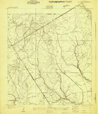 1926 Mauriceville1926 Print · USGSSoutheast Texas at the height of the mid-twenties rail era shows a landscape of timber-driven settlements and winding waterways. Genealogists and researchers can locate early schools and junctions like Little Cypress School, Lemonville, and Hartburg.
End of results
Showing maps 1-5 of 5
Top cities of Orange County
- Orange historical maps
- Vidor historical maps
- Bridge City historical maps
- West Orange historical maps
- Pinehurst historical maps
- Pine Forest historical maps
See more
Frequently asked questions
- What are the different types of historical maps available for Orange County?
- What is the oldest map of Orange County?
- Where can I purchase historical maps of Orange County for my home or office?
- Where can I download high-res historical maps of Orange County?
- Are there historical topographic maps available for Orange County?
- Is there historical aerial imagery available for Orange County?
- Where are historical maps of Orange County sourced from?