1980s Maps of Graford, Texas
Explore 3 historic maps of Graford from the 1980s. These maps offer a rare glimpse into what life looked like during the 1980s — showing old roads, neighborhoods, homes, and landmarks that have changed or disappeared over time.
Whether you're researching your family's past, planning a metal detecting trip, or studying how Graford's landscape evolved across the 1980s, these high-resolution maps are a powerful tool for exploring the history of this region.
- Focus on a specific era: All maps on this page are from the 1980s, giving you a focused view of this time period.
- See what’s changed: Compare century-old streets, trails, and buildings to today's modern landscape using overlays and satellite layers.
- Research with precision: Use these maps for genealogy, historical research, land use analysis, or educational projects.
- View, download, or print: Maps are fully viewable online in high resolution, and can be downloaded or printed for your own records.
Start exploring Graford's history through authentic maps from the 1980s. This is your window into the past.
Graford, TX maps
(3)- 1984 Map of Graford East
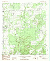 1984 Graford East1984 Print · USGSPalo Pinto County in the mid-1980s shows a landscape of winding creek forks and rural homesteads centered on the community of Oran. Genealogists and historians can trace local landmarks like Grindstone Mountain, Soda Springs Creek, and several rural Cem locations.
 - 1984 Map of Graford West
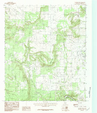 1984 Graford West1984 Print · USGSPalo Pinto County at the start of the 1980s shows a landscape of winding river bends and prairie highlands. Researchers can trace family-named landmarks like B C Harris Bend, the small community at Flatrock, and the rugged slopes of Mc Clure Mountain.2 unique versions available
 - 1985 Map of Mineral Wells
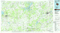 1985 Mineral Wells1985 Print · USGSNorth-central Texas in the mid-eighties shows a landscape of deep river valleys and massive reservoirs. Genealogists and historians can trace the Missouri Pacific rail line and locate rural settlements like Thurber, Necessity, and Palo Pinto.2 unique versions available
End of results
Showing maps 1-3 of 3
Top cities near Graford
- Mineral Wells historical maps
- Bryson historical maps
- Perrin historical maps
- Palo Pinto historical maps
- Cool historical maps
Frequently asked questions
- What are the different types of historical maps available for Graford?
- What is the oldest map of Graford?
- Where can I purchase historical maps of Graford for my home or office?
- Where can I download high-res historical maps of Graford?
- Are there historical topographic maps available for Graford?
- Is there historical aerial imagery available for Graford?
- Where are historical maps of Graford sourced from?