1920s Maps of Parker County, Texas
Explore 2 historic maps of Parker County from the 1920s. These maps offer a rare glimpse into what life looked like during the 1920s — showing old roads, neighborhoods, homes, and landmarks that have changed or disappeared over time.
Whether you're researching your family's past, planning a metal detecting trip, or studying how Parker County's landscape evolved across the 1920s, these high-resolution maps are a powerful tool for exploring the history of this region.
- Focus on a specific era: All maps on this page are from the 1920s, giving you a focused view of this time period.
- See what’s changed: Compare century-old streets, trails, and buildings to today's modern landscape using overlays and satellite layers.
- Research with precision: Use these maps for genealogy, historical research, land use analysis, or educational projects.
- View, download, or print: Maps are fully viewable online in high resolution, and can be downloaded or printed for your own records.
Start exploring Parker County's history through authentic maps from the 1920s. This is your window into the past.
Parker County, TX maps
(2)- 1924 Map of Weatherford 3-d
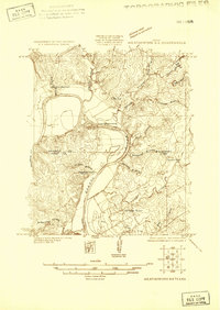 1924 Weatherford 3-d1924 Print · USGSParker and Hood counties are captured here in the mid-1920s as the river-cut landscape began to see early industrial infrastructure. Genealogists can trace early rural life through Walker School, the Hightower Bridge, and several family-named creek branches.
 - 1927 Map of Mineral Wells
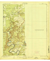 1927 Mineral Wells1927 Print · USGSThe Brazos River carves a winding path through Palo Pinto County in the mid-1920s, defining a landscape of deep hollows and sharp river bends. Researchers can trace early rural schools like Union Hill School and the route of the Weatherford Mineral Wells and Northwestern rail line.2 unique versions available
End of results
Showing maps 1-2 of 2
Top cities of Parker County
- Weatherford historical maps
- Willow Park historical maps
- Reno historical maps
- Springtown historical maps
- Aledo historical maps
- Hudson Oaks historical maps
See more
Frequently asked questions
- What are the different types of historical maps available for Parker County?
- What is the oldest map of Parker County?
- Where can I purchase historical maps of Parker County for my home or office?
- Where can I download high-res historical maps of Parker County?
- Are there historical topographic maps available for Parker County?
- Is there historical aerial imagery available for Parker County?
- Where are historical maps of Parker County sourced from?