1920s Maps of Alamo Ranchettes Colonia, Texas
Explore 3 historic maps of Alamo Ranchettes Colonia from the 1920s. These maps offer a rare glimpse into what life looked like during the 1920s — showing old roads, neighborhoods, homes, and landmarks that have changed or disappeared over time.
Whether you're researching your family's past, planning a metal detecting trip, or studying how Alamo Ranchettes Colonia's landscape evolved across the 1920s, these high-resolution maps are a powerful tool for exploring the history of this region.
- Focus on a specific era: All maps on this page are from the 1920s, giving you a focused view of this time period.
- See what’s changed: Compare century-old streets, trails, and buildings to today's modern landscape using overlays and satellite layers.
- Research with precision: Use these maps for genealogy, historical research, land use analysis, or educational projects.
- View, download, or print: Maps are fully viewable online in high resolution, and can be downloaded or printed for your own records.
Start exploring Alamo Ranchettes Colonia's history through authentic maps from the 1920s. This is your window into the past.
Alamo Ranchettes Colonia, TX maps
(3)- 1921 Map of Fort Stockton, 1965 Print
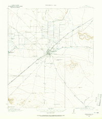 1921 Fort Stockton1965 Print · USGSPecos County ranching and rail life are documented here during the early twenties, centered on the hub of Fort Stockton. Genealogists and historians can locate family landmarks like the Odom Ranch, Old Martin Place, and rural Leon Valley School.
 - 1923 Map of Fort Stockton
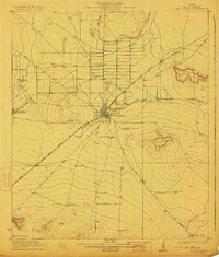 1923 Fort Stockton1923 Print · USGSWest Texas ranching and rail commerce thrive in this early 1920s portrait of Pecos County. Genealogists and historians can locate family-named landmarks like Brannon Ranch and Odom Ranch or trace the early paths of the Kansas City Mexico and Orient railroad.
 - 1928 Map of Comanche Spring
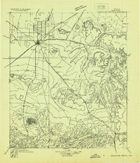 1928 Comanche Spring1928 Print · USGSWest Texas ranching and transportation intersect in the late twenties near the historic waters of Comanche Spring. Researchers can trace early highway routes like the Old Spanish Trail and find remote rail sidings at Elsinore and Scharbaugh.
End of results
Showing maps 1-3 of 3
Top cities near Alamo Ranchettes Colonia
Frequently asked questions
- What are the different types of historical maps available for Alamo Ranchettes Colonia?
- What is the oldest map of Alamo Ranchettes Colonia?
- Where can I purchase historical maps of Alamo Ranchettes Colonia for my home or office?
- Where can I download high-res historical maps of Alamo Ranchettes Colonia?
- Are there historical topographic maps available for Alamo Ranchettes Colonia?
- Is there historical aerial imagery available for Alamo Ranchettes Colonia?
- Where are historical maps of Alamo Ranchettes Colonia sourced from?