1970s Maps of Smith Place, Texas
Explore 2 historic maps of Smith Place from the 1970s. These maps offer a rare glimpse into what life looked like during the 1970s — showing old roads, neighborhoods, homes, and landmarks that have changed or disappeared over time.
Whether you're researching your family's past, planning a metal detecting trip, or studying how Smith Place's landscape evolved across the 1970s, these high-resolution maps are a powerful tool for exploring the history of this region.
- Focus on a specific era: All maps on this page are from the 1970s, giving you a focused view of this time period.
- See what’s changed: Compare century-old streets, trails, and buildings to today's modern landscape using overlays and satellite layers.
- Research with precision: Use these maps for genealogy, historical research, land use analysis, or educational projects.
- View, download, or print: Maps are fully viewable online in high resolution, and can be downloaded or printed for your own records.
Start exploring Smith Place's history through authentic maps from the 1970s. This is your window into the past.
Smith Place, TX maps
(2)- 1970 Map of Belding SW, 1973 Print
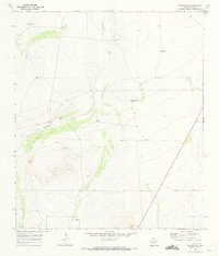 1970 Belding SW1973 Print · USGSPecos County ranching life in the early 1970s is captured here, centered on the drainage of the Coyanosa Draw. Genealogists and researchers can trace family-named sites like Kennedy Ranch and the Smith Place alongside numerous named wells and windmills.
 - 1973 Map of Fort Stockton, 1974 Print
 1973 Fort Stockton1974 Print · USGSThe Trans-Pecos region of West Texas comes alive in the early seventies, from the desert flats of the Stockton Plateau to the heights of the Davis Mountains. Researchers can trace the legacy of frontier outposts and rail lines through Fort Davis Nat Hist Site, Alpine, and the Southern Pacific RR.
End of results
Showing maps 1-2 of 2
Frequently asked questions
- What are the different types of historical maps available for Smith Place?
- What is the oldest map of Smith Place?
- Where can I purchase historical maps of Smith Place for my home or office?
- Where can I download high-res historical maps of Smith Place?
- Are there historical topographic maps available for Smith Place?
- Is there historical aerial imagery available for Smith Place?
- Where are historical maps of Smith Place sourced from?