1980s Maps of Plata, Texas
Explore 2 historic maps of Plata from the 1980s. These maps offer a rare glimpse into what life looked like during the 1980s — showing old roads, neighborhoods, homes, and landmarks that have changed or disappeared over time.
Whether you're researching your family's past, planning a metal detecting trip, or studying how Plata's landscape evolved across the 1980s, these high-resolution maps are a powerful tool for exploring the history of this region.
- Focus on a specific era: All maps on this page are from the 1980s, giving you a focused view of this time period.
- See what’s changed: Compare century-old streets, trails, and buildings to today's modern landscape using overlays and satellite layers.
- Research with precision: Use these maps for genealogy, historical research, land use analysis, or educational projects.
- View, download, or print: Maps are fully viewable online in high resolution, and can be downloaded or printed for your own records.
Start exploring Plata's history through authentic maps from the 1980s. This is your window into the past.
Plata, TX maps
(2)- 1983 Map of Plata NE
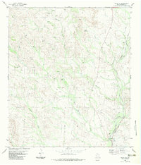 1983 Plata NE1983 Print · USGSPresidio County ranching lands and the Big Bend backcountry are revealed here in the early eighties. Genealogists and historians can trace the rail corridor of the Atchison Topeka and Santa Fe near Alamito and Perkins Ranch.
 - 1985 Map of Presidio
 1985 Presidio1985 Print · USGSThe Big Bend borderlands come into focus in the 1980s as the rail lines of the Atchison Topeka and Santa Fe reach the Rio Grande. Historians can trace mining operations at Shafter and Burney Mine or locate river outposts like Adobes.
End of results
Showing maps 1-2 of 2
Frequently asked questions
- What are the different types of historical maps available for Plata?
- What is the oldest map of Plata?
- Where can I purchase historical maps of Plata for my home or office?
- Where can I download high-res historical maps of Plata?
- Are there historical topographic maps available for Plata?
- Is there historical aerial imagery available for Plata?
- Where are historical maps of Plata sourced from?