Old Maps of Red River County, Texas
Explore 196 old maps of Red River County, spanning from 1930 to today. These high-resolution historic maps reveal how streets, neighborhoods, landmarks, and natural features evolved over time — perfect for genealogy, metal detecting, research, and local history exploration.
What you can do with these maps:
- See how Red River County changed over time: Compare historical maps to modern-day views to trace roads, homesites, rail lines & more.
- View detailed metadata: Each map includes creators, publishers, year, scale, and archive source.
- Overlay maps with satellite & LiDAR: Visualize the past alongside modern tools to explore terrain & human change.
- Trusted historical sources: Maps sourced from the USGS, Library of Congress, and other archives.
- Access maps your way: View online, download high-res files, or order prints for personal or research use.
Start exploring old maps of Red River County to uncover forgotten places, hidden landmarks, and the deep history beneath your feet.
Red River County, TX maps
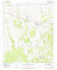
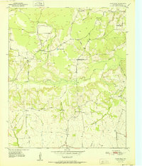
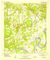
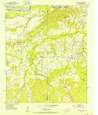
(196)- 1930 Map of Bassett
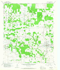
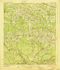 1930 Bassett1930 Print · USGSBowie and Cass Counties are captured here as the traditional rural landscape met the expanding reach of the railroad and early oil exploration. Genealogists can locate many namesake schools and churches like Big Woods Sch, Mt Zion Ch, and the settlement of White Cotton.2 unique versions available
 - 1950 Map of Acworth, 1968 Print
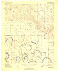
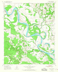 1950 Acworth1968 Print · USGSThe Red River borderlands of Texas and Oklahoma are captured here at mid-century as a landscape of shifting waters and rural communities. Genealogists can trace family roots through landmarks like Greenwood Ch, Bachman Cem, and the old Acworth Sch along the river's winding oxbows.
 - 1950 Map of De Kalb NW, 1969 Print
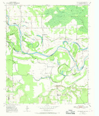 1950 De Kalb NW1969 Print · USGSThe Red River valley at the Texas-Oklahoma border comes alive here during the mid-century, showing a landscape shaped by shifting waters and rural settlement. Researchers can trace family roots through sites like Harris Cem, Antioch Ch, and the many local schoolhouses like Field Ridge Sch.2 unique versions available
 - 1950 Map of White Rock, 1973 Print
 1950 White Rock1973 Print · USGSNortheast Texas rural life in the mid-twentieth century is centered on the small hamlets and bayous of Red River County. Genealogists can locate family landmarks like Slate Cem, the Madras Sch, and the dispersed houses of Reeds Settlement.2 unique versions available
 - 1950 Map of Oak Grove, 1976 Print
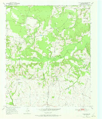
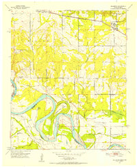
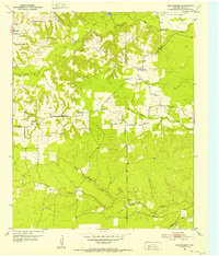
 1950 Oak Grove1976 Print · USGSBowie County at the midpoint of the century shows a landscape of small rail-side communities and scattered country parishes. Genealogists can trace family footprints near Oak Grove, Garland, and rural landmarks like Gravel Hill Ch or the Garland Cem.
 - 1950 Map of Annona, 1977 Print
 1950 Annona1977 Print · USGSNortheast Texas at mid-century reveals a landscape of dispersed rural communities and small-town rail commerce. Genealogists and local historians can trace the foundations of Red River County through sites like Lanes Chapel Cem, Annona, and Swanville Ch.
 - 1951 Map of Idabel SE
 1951 Idabel SE1951 Print · USGSThe Oklahoma-Texas border along the Red River is captured here in the early fifties, showing a landscape of shifting oxbows and rural social hubs. Researchers can trace local history through the St Louis San Francisco rail line and sites like Kullituklo Ch and Richland Sch.2 unique versions available
 - 1951 Map of English
 1951 English1951 Print · USGSRed River County during the early 1950s shows a landscape shaped by the shifting channel of the Red River. Genealogists and local historians can trace family roots through the sites of Martin-Shiloh Ch, the Hale Sch, and the settlement of English.2 unique versions available
 - 1951 Map of Annona
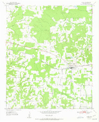
 1951 Annona1951 Print · USGSAnnona was a vital rail stop in Red River County during the early 1950s, anchoring a network of rural schools and family chapels. Genealogists can trace local landmarks like Lanes Chapel Sch, Garland Cem, and King Memorial Chapel.
 - 1951 Map of White Rock
 1951 White Rock1951 Print · USGSRed River County in the early fifties remains a landscape of quiet rural crossroads and tight-knit farming communities. Researchers can trace the heritage of local families at White Rock Cem, Reeds Settlement, and country schools like Madras Sch.
 - 1951 Map of De Kalb NW
 1951 De Kalb NW1951 Print · USGSThe Red River valley at the Oklahoma-Texas border is captured here in the early fifties, showing a landscape shaped by shifting river bends. Genealogists and local historians can trace the locations of Riverside Sch, Antioch Ch, and family landmarks like Jim Jones Hill.
 - 1951 Map of Oak Grove
 1951 Oak Grove1951 Print · USGSBowie County at the dawn of the 1950s shows a landscape of rural communities tied together by the Texas and Pacific rail line. Genealogists can trace family footprints at Mt Pleasant Sch, Garland Cem, and West Bowie Union Ch.
 - 1951 Map of Acworth
 1951 Acworth1951 Print · USGSThe Texas-Oklahoma borderlands along the Red River are captured here in the early fifties, documenting a landscape of river-bend oxbows and rural farmsteads. Trace the locations of historic community hubs like Acworth, the Bachman Cem, and local schools including Greenwood Sch.
 - 1951 Map of Avery
 1951 Avery1951 Print · USGSRed River County settlement in the early fifties revolves around the rail stop at Avery. Genealogists and local historians can locate many small rural burial grounds and sanctuaries, including Honeycutt Cem, Savannah Ch, and Mill Creek Sch.
 - 1951 Map of Frogville, 1952 Print
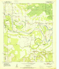
 1951 Frogville1952 Print · USGSThe Oklahoma-Texas borderlands along the Red River are captured here in the early fifties, showing a landscape defined by meandering river bends. Genealogists can locate numerous local burial sites and schools like Frogville Cem, Everidge Cem, and Lake View Sch.3 unique versions available
 - 1951 Map of Millerton, 1952 Print
 1951 Millerton1952 Print · USGSThe Red River borderlands are captured here in the early fifties, showing the winding river meanders between Oklahoma and Texas. Genealogists and historians can locate rural landmarks like Clear Creek Ch, Redland Sch, and the St Louis San Francisco rail line.2 unique versions available
 - 1951 Map of Negley, 1952 Print
 1951 Negley1952 Print · USGSRed River County at the dawn of the fifties shows a landscape of river-bottom farms and small rural outposts along the Oklahoma border. Genealogists can locate family homes and community centers like Albion Sch, Tuggle Springs Cem, and Negley PO.3 unique versions available
 - 1951 Map of Kiomatia, 1952 Print
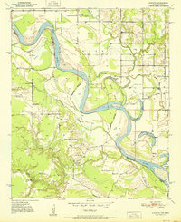
 1951 Kiomatia1952 Print · USGSThe Red River valley at the Texas-Oklahoma border comes alive in the early fifties, showing a dense network of rural schools and river-bottom farms. Genealogists can trace family footprints at Kiomatia, Siloam Church, and the Kiomatia Agricultural School.
 - 1951 Map of Woodland, 1952 Print
 1951 Woodland1952 Print · USGSThe Red River Valley's borderlands in the early fifties are captured here as a landscape of small agricultural hamlets and riverfront boundaries. Researchers can trace rural community life through landmarks like Lone Star Sch, Woodland Cem, and the crossing at Pin Hook.2 unique versions available
 - 1951 Map of Manchester, 1952 Print
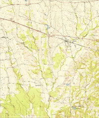
 1951 Manchester1952 Print · USGSRed River County, Texas, is shown in the early fifties as a landscape of rural school-and-church communities and wooded creek bottoms. Researchers can locate the Calhoun Cem, trace the roads connecting Addielou to Manchester, and find an early Oil Well near Bible Way Ch.
 - 1953 Map of Texarkana, 1964 Print
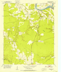
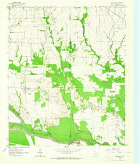
 1953 Texarkana1964 Print · USGSThe Texas-Arkansas borderlands are captured here in the mid-fifties, during a decade of massive military and hydraulic engineering projects. Genealogists and researchers can locate family landmarks like Old Boston Cem, Siloam Ch, and the vast Red River Arsenal.4 unique versions available
 - 1956 Map of Texarkana
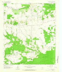
 1956 Texarkana1956 Print · USGSThe Ark-La-Tex borderlands come alive in the mid-fifties, showing the transition from a rail-dependent rural economy to a post-war industrial landscape. Researchers can trace the massive Red River Ordnance Depot and find towns like Talco, Bogata, and Naples.
 - 1963 Map of Mitchell Creek, 1964 Print
 1963 Mitchell Creek1964 Print · USGSNortheast Texas rural life and industrial growth intersect in the 1960s at the convergence of four counties. Trace family history at Fairview Ch or the Shell Oil Field and explore the bottoms of the South Sulphur River.
 - 1963 Map of Cunningham, 1964 Print
 1963 Cunningham1964 Print · USGSNortheast Texas river country in the early sixties reveals a landscape shaped by the meeting of the North and South Sulphur Rivers. Researchers can locate family landmarks like Restland Cem and Morris Chapel Cem near the historic settlements of Cunningham and Halesboro.
 - 1964 Map of Detroit, 1967 Print
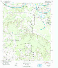
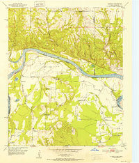
 1964 Detroit1967 Print · USGSThe railroad corridor and fertile creek bottoms of Red River and Lamar counties are captured here in the mid-1960s. Genealogists can trace family footprints at Egypt Cemetery, New Hope Church, and the community of Post Oak.
Showing maps 1-25 of 196
Top cities of Red River County
- Clarksville historical maps
- Bogata historical maps
- Detroit historical maps
- Avery historical maps
- Annona historical maps
Frequently asked questions
- What are the different types of historical maps available for Red River County?
- What is the oldest map of Red River County?
- Where can I purchase historical maps of Red River County for my home or office?
- Where can I download high-res historical maps of Red River County?
- Are there historical topographic maps available for Red River County?
- Is there historical aerial imagery available for Red River County?
- Where are historical maps of Red River County sourced from?