1960s Maps of Red River County, Texas
Explore 16 historic maps of Red River County from the 1960s. These maps offer a rare glimpse into what life looked like during the 1960s — showing old roads, neighborhoods, homes, and landmarks that have changed or disappeared over time.
Whether you're researching your family's past, planning a metal detecting trip, or studying how Red River County's landscape evolved across the 1960s, these high-resolution maps are a powerful tool for exploring the history of this region.
- Focus on a specific era: All maps on this page are from the 1960s, giving you a focused view of this time period.
- See what’s changed: Compare century-old streets, trails, and buildings to today's modern landscape using overlays and satellite layers.
- Research with precision: Use these maps for genealogy, historical research, land use analysis, or educational projects.
- View, download, or print: Maps are fully viewable online in high resolution, and can be downloaded or printed for your own records.
Start exploring Red River County's history through authentic maps from the 1960s. This is your window into the past.
Red River County, TX maps
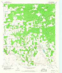
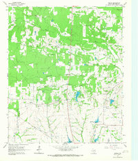
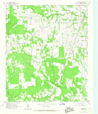
(16)- 1963 Map of Mitchell Creek, 1964 Print
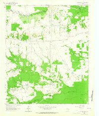 1963 Mitchell Creek1964 Print · USGSNortheast Texas rural life and industrial growth intersect in the 1960s at the convergence of four counties. Trace family history at Fairview Ch or the Shell Oil Field and explore the bottoms of the South Sulphur River.
 - 1963 Map of Cunningham, 1964 Print
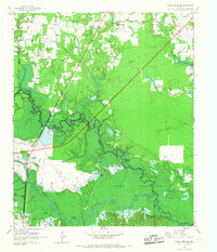
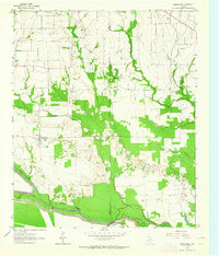 1963 Cunningham1964 Print · USGSNortheast Texas river country in the early sixties reveals a landscape shaped by the meeting of the North and South Sulphur Rivers. Researchers can locate family landmarks like Restland Cem and Morris Chapel Cem near the historic settlements of Cunningham and Halesboro.
 - 1964 Map of Detroit, 1967 Print
 1964 Detroit1967 Print · USGSThe railroad corridor and fertile creek bottoms of Red River and Lamar counties are captured here in the mid-1960s. Genealogists can trace family footprints at Egypt Cemetery, New Hope Church, and the community of Post Oak.
 - 1964 Map of Deport, 1967 Print
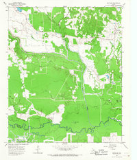
 1964 Deport1967 Print · USGSDeport and the surrounding Lamar County countryside are captured here in the mid-sixties, showing a landscape of small farming communities and winding creeks. Genealogists can locate several family landmarks and burial sites, including Wrights Chapel Cem, the Birthplace of John N. Garner, and Milton.
 - 1964 Map of Bagwell, 1967 Print
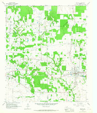
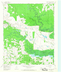
 1964 Bagwell1967 Print · USGSRed River County in the mid-sixties remains a landscape of small rail-side settlements and scattered rural cemeteries. Genealogists and historians can trace family ties through Longstreet Cem and Dean Cem or follow the TEXAS AND PACIFIC line through Bagwell.
 - 1964 Map of Cuthand, 1967 Print
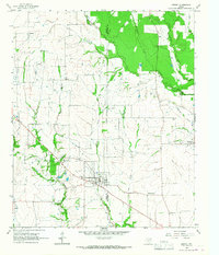
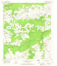
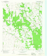
 1964 Cuthand1967 Print · USGSRed River County in the mid-1960s was a landscape of river-bottom industry and scattered rural settlements. Genealogists and historians can trace family locations near Cuthand, locate the McKinzie Ch, or study the footprint of the Trix-Liz Oil Field.
 - 1964 Map of Hagansport, 1967 Print
 1964 Hagansport1967 Print · USGSFranklin County during the mid-sixties reveals a landscape shaped by the Talco Oil Field and the winding Sulphur River. Genealogists can locate community anchors like Hagansport, Prairie Academy Cem, and Mt Olive Ch.
 - 1964 Map of Bogata, 1967 Print
 1964 Bogata1967 Print · USGSThe town of Bogata and the surrounding Red River County countryside are captured here in the mid-1960s. Researchers can trace family history at Dodds Cem and Hinson Cem or locate industrial sites like the Talco City Pumping Sta and the Old Railroad Grade.
 - 1964 Map of Dimple, 1967 Print
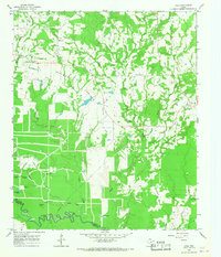
 1964 Dimple1967 Print · USGSRed River County in the mid-sixties shows a landscape of creek-side settlements and managed water. Genealogists can locate family landmarks like Whitemans Chapel Cemetery, State Rock Church, and the rural community of Dimple.
 - 1964 Map of Line Branch, 1967 Print
 1964 Line Branch1967 Print · USGSRed River County’s agricultural and oil-producing heartland is captured here in the mid-1960s. Genealogists can trace family footprints through sites like Lone Star Cem, Turner Cem, and the small settlements of Fulbright and Liberty.
 - 1964 Map of Clarksville, 1968 Print
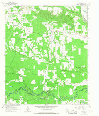
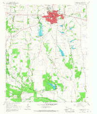 1964 Clarksville1968 Print · USGSRed River County centers on the busy hub of Clarksville in the mid-1960s, showing a landscape defined by the railroad and rural school districts. Genealogists and researchers can trace family landmarks like McKenzie Cemetery, the McKenzie College Historical Monument, and the route of the Texas and Pacific railroad.
 - 1965 Map of Lydia, 1967 Print
 1965 Lydia1967 Print · USGSThe Red River and Titus county line in the mid-1960s follows the meandering Sulphur River through a landscape of prairies and family cemeteries. Genealogists can locate numerous burial sites like Cedar Creek Cem, Baker Cem, and Wilkes Cem.
 - 1965 Map of Hodgson, 1967 Print
 1965 Hodgson1967 Print · USGSBowie County and the eastern edge of Red River County appear here in the mid-1960s, showing a landscape of prairies and creek-side settlements. Researchers can locate the Big Woods Ch, Cedar Creek Cem, and the communities of New Hope and Hodgson.2 unique versions available
 - 1965 Map of Dalby Springs, 1967 Print
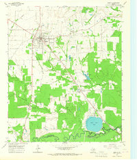
 1965 Dalby Springs1967 Print · USGSBowie County and the Sulphur River bottomlands are captured here in the mid-1960s during a period of significant hydraulic change. Genealogists and local historians can trace family sites like Roberts Cem, the village of Dalby, and the rising shoreline of Lake Texarkana.2 unique versions available
 - 1965 Map of Boxelder, 1967 Print
 1965 Boxelder1967 Print · USGSRed River County in the mid-1960s was a landscape of winding bottomland creeks and emerging petroleum activity. Researchers can trace family sites near Boxelder, find the Evergreen Cem, or locate landmarks like Harts Bluff and the Trix-Liz Oil Field.2 unique versions available
 - 1965 Map of Coopers Chapel, 1968 Print
 1965 Coopers Chapel1968 Print · USGSNortheast Texas in the 1960s was a landscape of winding river bottoms and small rural outposts. Genealogists and historians can trace family locations near Coopers Chapel, the Evergreen Cem, and the industry of the Pewitt Ranch Oil Field.2 unique versions available
End of results
Showing maps 1-16 of 16
Top cities of Red River County
- Clarksville historical maps
- Bogata historical maps
- Detroit historical maps
- Avery historical maps
- Annona historical maps
Frequently asked questions
- What are the different types of historical maps available for Red River County?
- What is the oldest map of Red River County?
- Where can I purchase historical maps of Red River County for my home or office?
- Where can I download high-res historical maps of Red River County?
- Are there historical topographic maps available for Red River County?
- Is there historical aerial imagery available for Red River County?
- Where are historical maps of Red River County sourced from?