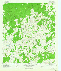
Old Maps of Robertson County, Texas for Metal Detecting
Plan your next treasure hunt with 169 historic maps of Robertson County. Find old homesites, ghost towns, trails, and gathering spots that may be lost to time — perfect for identifying promising metal detecting locations.
- Locate forgotten sites: Uncover places like long-lost settlements, abandoned rail lines, or gathering spots.
- Plan better hunts: Use map overlays combined with LiDAR or satellite views to narrow in on historically rich areas.
- Made for detectorists: Thousands of hobbyists use these maps to discover relics, coins, and hidden history.
Use these historic maps to boost your research and find new opportunities beneath the surface of Robertson County.
Robertson County, TX maps
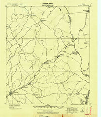
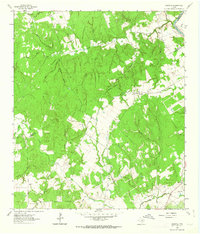
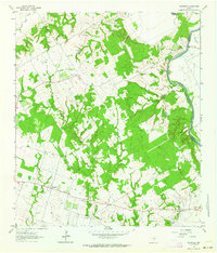
(169)- 1925 Map of Iola No 2
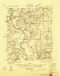 1925 Iola No 21925 Print · USGSThe Navasota River bottomlands at the Madison and Leon county line appear here in the mid-1920s as a landscape of winding oxbows and rural farmsteads. Researchers can locate family landmarks such as Keefer Cemetery, Burns Store, and the Morning Star School site.
 - 1925 Map of Marquez No. 1
 1925 Marquez No. 11925 Print · USGSThe Navasota River valley in the mid-1920s reveals a rural Texas landscape at the border of Leon and Robertson counties. Local researchers can locate vanished landmarks like Dolly School, the town of Venetia, and the historic Great Northern Trail.
 - 1925 Map of Marquez No. 4
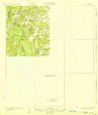
 1925 Marquez No. 41925 Print · USGSThe Navasota River bottomlands in the mid-twenties were a complex maze of marshes and oxbows along the Robertson and Leon county line. Genealogists can locate rural schoolhouses like Elm Grove School or Navasota School and trace the early Pipe Line corridor near Easterly.
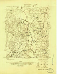
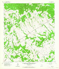
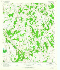
 - 1927 Map of Marquez
 1927 Marquez1927 Print · USGSThe Leon and Robertson county border in the 1920s was a landscape of small schools and river-bottom bottomlands centered on the Marquez settlement. Genealogists can trace family roots at Camp Creek Cemetery or locate old schoolhouses like Dolly School and Blue Grove School.2 unique versions available
 - 1930 Map of Marquez
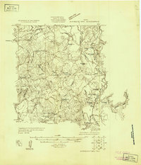
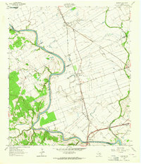
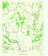
 1930 Marquez1930 Print · USGSRobertson and Leon counties are mapped here at the height of the steam-rail era. Genealogists can trace family footprints through rural post offices like Bald Prairie P.O. and community anchors like Holly Church and James School.
 - 1931 Map of Iola
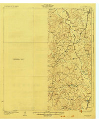
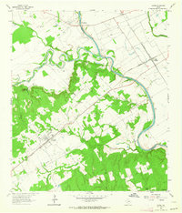
 1931 Iola1931 Print · USGSThe Navasota River basin in the mid-1920s shows a landscape of river-bottom lakes and rural outposts. Genealogists can locate family landmarks like Keefer Cem and Nash Cem or the local hub at Burns Store.2 unique versions available
 - 1954 Map of Waco, 1964 Print
 1954 Waco1964 Print · USGSCentral Texas during the mid-fifties shows a landscape defined by the expansion of Fort Hood Military Reservation and the Brazos river system. Trace the rail lines and early airfields like James Connally Air Force Base and settlements like Temple or McGregor.2 unique versions available
 - 1954 Map of Austin, 1964 Print
 1954 Austin1964 Print · USGSCentral Texas is captured during a period of steady growth as the capital city and its neighboring farm towns began to modernize. Researchers can trace historic rail corridors like the Southern Pacific RR or locate landmarks such as Bergstrom Air Force Base and Pilot Knob.4 unique versions available
 - 1955 Map of Waco
 1955 Waco1955 Print · USGSCentral Texas at the peak of the Cold War reveals a landscape defined by military expansion and major water projects. Researchers can trace the footprints of Fort Hood, the waters of Lake Waco, and regional hubs like Temple or Mexia.
 - 1956 Map of Bryan
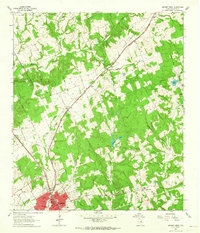
 1956 Bryan1956 Print · USGSBrazos County is shown in the era of early college expansion and steam rail, centered on the growing campus of Texas A&M College. Genealogists and historians can trace defunct post offices and rural school sites like Benchley P.O., Woodville School, and the settlement of Boonville.
 - 1956 Map of Caldwell
 1956 Caldwell1956 Print · USGSThe Brazos Valley at the end of the Great War era shows a landscape defined by cotton gins and river crossings. Trace family roots and vanished landmarks like Moseley's Ferry, Stone City, and the Skrabonek Gin near Caldwell.
 - 1961 Map of Mumford, 1964 Print
 1961 Mumford1964 Print · USGSThe Brazos River valley in the early sixties is a landscape of rural junctions and historic outposts at the meeting point of four counties. Researchers can locate the Fort Tenoxtitlan (Site), the rail sidings at Mudville, and local landmarks like Smith Sch.3 unique versions available
 - 1961 Map of Hearne North, 1964 Print
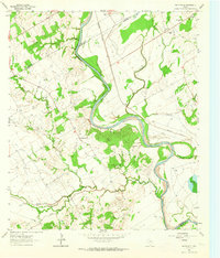
 1961 Hearne North1964 Print · USGSHearne and the surrounding Robertson County prairies are captured in the early sixties as a bustling rail and transit hub. Genealogists can locate family landmarks like Hammond Colony, Blackshear High Sch, and the Norwood Cem among the creek breaks.2 unique versions available
 - 1961 Map of Baileyville, 1964 Print
 1961 Baileyville1964 Print · USGSIn the early sixties, this rural intersection of Milam, Falls, and Robertson Counties was defined by its winding river bottomlands and family farmsteads. Researchers can locate family landmarks like Bozeman Cem, Morning Star Ch, and the Hooper Ranch.2 unique versions available
 - 1961 Map of Hearne South, 1964 Print
 1961 Hearne South1964 Print · USGSRailroad operations in the Brazos Valley defined the early 1960s landscape near the Milam and Robertson County line. Genealogists and local historians can trace the footprint of rural communities through sites like Tatsie Crossing, St Luke Cem, and the Blackshear High Sch.3 unique versions available
 - 1962 Map of Goodwill, 1963 Print
 1962 Goodwill1963 Print · USGSThe rural borderlands of Burleson and Milam counties are captured here in the early 1960s, centered on the community of Hix. Genealogists and local historians can trace the foundations of this area through St Mathews Ch, the Hix Cem, and family-named hollows like Bailey Hollow.2 unique versions available
 - 1962 Map of Edge, 1964 Print
 1962 Edge1964 Print · USGSRobertson and Brazos counties in the early sixties remain a landscape of small rural settlements and family cemeteries. Genealogy researchers can trace local roots at Edge, Shiloh Ch, and the historic Kings Highway that cuts through the region.2 unique versions available
 - 1962 Map of Calvert, 1964 Print
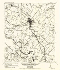
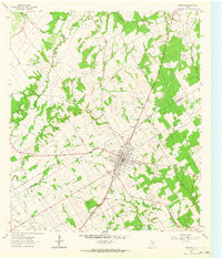
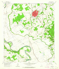 1962 Calvert1964 Print · USGSCentral Robertson County's agricultural and rail heart is captured here in the early sixties. Researchers can trace family roots through the Calvert Cem, identify local schools like Spikes High Sch, and locate rural settlements near Marvin and Barton.3 unique versions available
 - 1962 Map of Wheelock, 1964 Print
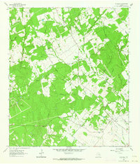 1962 Wheelock1964 Print · USGSIn the early 1960s, the Robertson and Brazos county line was a landscape of rural schoolhouse-era churches and family cemeteries. Researchers can find ancestral sites at Wheelock Cem, Cavit Cem, and the historic Henry Prairie Ch.3 unique versions available
 - 1962 Map of Maysfield, 1964 Print
 1962 Maysfield1964 Print · USGSMilam County farming communities and the Brazos River valley are captured here in the early sixties. Researchers can locate numerous family-history sites like Harlin Chapel Cem, the Maysfield Sch, and the riverside crossing at Black Bridge.2 unique versions available
 - 1962 Map of Hammond, 1964 Print
 1962 Hammond1964 Print · USGSThe rural Robertson County landscape comes alive in this early 1960s survey, showing a time when small communities were still centered around their country schools and churches. Genealogists and historians can trace family roots through landmarks like Hammond High Sch, Bethlehem Cem, and Mt Moriah Ch.3 unique versions available
 - 1962 Map of Reagan, 1964 Print
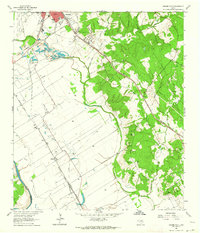
 1962 Reagan1964 Print · USGSThe Brazos River valley in the early sixties remains a landscape of rail-side settlements and rural congregations. Researchers can trace family history through Washington Cem, Bowman Chapel, and the communities of Highbank and Reagan.2 unique versions available
 - 1962 Map of Gause, 1964 Print
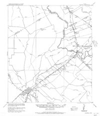
 1962 Gause1964 Print · USGSMilam and Robertson counties are captured here in the early sixties as the rail and river networks defined local life. Trace the old river port at Port Sullivan or locate ancestral sites like Nashville Cem and Stephen Chapel near the town of Gause.2 unique versions available
 - 1962 Map of Bremond, 1964 Print
 1962 Bremond1964 Print · USGSBremond was a bustling railroad town in the early sixties, anchored by the Southern Pacific line and a tight-knit community of schools and churches. Genealogists can trace family names through several rural burial grounds including St Mary Cem and Cloverleaf Rest Cem.2 unique versions available
 - 1962 Map of Petteway, 1964 Print
 1962 Petteway1964 Print · USGSThe rural borderlands of Robertson and Limestone counties come into focus in the early sixties. Genealogists and local historians can trace family-named watercourses and community landmarks like Post Oak Sch, Petteway Ch, and the waters of Hurricane Creek.2 unique versions available
Showing maps 1-25 of 169
Top cities of Robertson County
Frequently asked questions
- What are the different types of historical maps available for Robertson County?
- What is the oldest map of Robertson County?
- Where can I purchase historical maps of Robertson County for my home or office?
- Where can I download high-res historical maps of Robertson County?
- Are there historical topographic maps available for Robertson County?
- Is there historical aerial imagery available for Robertson County?
- Where are historical maps of Robertson County sourced from?