1900s (20th Century) Maps of Henderson, Texas
Explore 7 historic maps of Henderson from the 1900s (20th Century). These maps offer a rare glimpse into what life looked like during the 1900s — showing old roads, neighborhoods, homes, and landmarks that have changed or disappeared over time.
Whether you're researching your family's past, planning a metal detecting trip, or studying how Henderson's landscape evolved across the 1900s, these high-resolution maps are a powerful tool for exploring the history of this region.
- Focus on a specific era: All maps on this page are from the 1900s, giving you a focused view of this time period.
- See what’s changed: Compare century-old streets, trails, and buildings to today's modern landscape using overlays and satellite layers.
- Research with precision: Use these maps for genealogy, historical research, land use analysis, or educational projects.
- View, download, or print: Maps are fully viewable online in high resolution, and can be downloaded or printed for your own records.
Start exploring Henderson's history through authentic maps from the 1900s. This is your window into the past.
Henderson, TX maps
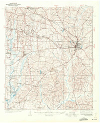
(7)- 1935 Map of Henderson
 1935 Henderson1935 Print · USGSRusk County in the mid-1930s is a landscape defined by the East Texas oil boom and its sprawling rural communities. Researchers can trace early family sites like Old London Cemetery and Duncan Cemetery or locate industrial landmarks like the Lisbon Gasoline Company Plant.
 - 1939 Map of Henderson
 1939 Henderson1939 Print · USGSRusk County at the peak of the 1930s oil boom reveals a landscape of rapidly growing settlements and dense rural infrastructure. Researchers can trace the footprints of Joinerville, Old London, and Gaston School alongside the Missouri Pacific rail line.
 - 1956 Map of Tyler
 1956 Tyler1956 Print · USGSEast Texas was a powerhouse of oil production and rail transport during the mid-fifties, centered on the sprawling East Texas Oil Field. Researchers can trace the heritage of industrial hubs like Kilgore, military sites such as the Longhorn Ordnance Works, and many rural landmarks like Mount Enterprise.5 unique versions available
 - 1973 Map of Henderson, 1975 Print
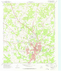 1973 Henderson1975 Print · USGSHenderson and its surrounding Rusk County suburbs are captured during a period of industrial and residential growth in the early seventies. Genealogists can locate several family burial grounds like Oberthier Cem and New Hope Cem while tracing the Missouri Pacific rail line.2 unique versions available
 - 1973 Map of Berryhill Creek, 1977 Print
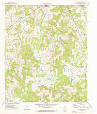 1973 Berryhill Creek1977 Print · USGSRusk County is captured in the early seventies, showing a landscape of East Texas timberlands shaped by the oil industry and rural faith. Researchers can find old family-named sites like Crow Cem, Lockhart Cem, and Union Grove Ch.
 - 1984 Map of Tyler
 1984 Tyler1984 Print · USGSEast Texas at the peak of its reservoir-building era shows a landscape defined by new lakes and established rail corridors. Trace the path of the St Louis Southwestern RR or locate industrial sites like the Longhorn Ordnance Works.3 unique versions available
 - 1986 Map of Henderson
 1986 Henderson1986 Print · USGSEast Texas and the Louisiana borderlands come into focus in the 1980s as industrial energy production meets quiet rural townships. Researchers can trace family sites and local landmarks from Elysian Fields to Old Panola, alongside major features like the Strip Mine and Martin Lake State Park.2 unique versions available
End of results
Showing maps 1-7 of 7
Top cities near Henderson
Top neighborhoods of Henderson
Frequently asked questions
- What are the different types of historical maps available for Henderson?
- What is the oldest map of Henderson?
- Where can I purchase historical maps of Henderson for my home or office?
- Where can I download high-res historical maps of Henderson?
- Are there historical topographic maps available for Henderson?
- Is there historical aerial imagery available for Henderson?
- Where are historical maps of Henderson sourced from?