1960s Maps of Taft, Texas
Explore 4 historic maps of Taft from the 1960s. These maps offer a rare glimpse into what life looked like during the 1960s — showing old roads, neighborhoods, homes, and landmarks that have changed or disappeared over time.
Whether you're researching your family's past, planning a metal detecting trip, or studying how Taft's landscape evolved across the 1960s, these high-resolution maps are a powerful tool for exploring the history of this region.
- Focus on a specific era: All maps on this page are from the 1960s, giving you a focused view of this time period.
- See what’s changed: Compare century-old streets, trails, and buildings to today's modern landscape using overlays and satellite layers.
- Research with precision: Use these maps for genealogy, historical research, land use analysis, or educational projects.
- View, download, or print: Maps are fully viewable online in high resolution, and can be downloaded or printed for your own records.
Start exploring Taft's history through authentic maps from the 1960s. This is your window into the past.
Taft, TX maps
(4)- 1960 Map of Corpus Christi
 1960 Corpus Christi1960 Print · USGSCoastal South Texas and the Nueces County hinterlands are detailed in this mid-century survey. Genealogists and historians can trace early settlement patterns and rural landmarks like Casa Blanca during a period of steady regional growth.
 - 1966 Map of Corpus Christi
 1966 Corpus Christi1966 Print · USGSThe Texas Coastal Bend in the mid-1960s reveals a landscape where massive cattle empires and strategic military bases meet the Gulf. Trace the vast reaches of King Ranch or locate aviation history at the Corpus Christi Air Station and Kingsville Air Station.
 - 1969 Map of Taft, 1972 Print
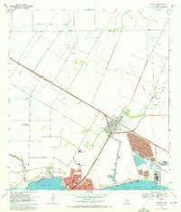
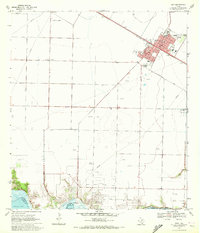 1969 Taft1972 Print · USGSCoastal Texas industry and civic life intersect in the late sixties as oil production expands around Taft. Trace local genealogy and infrastructure through the Bellevue Cem, Worsham Airfield, and the sprawling White Point Oil Field.2 unique versions available
 - 1969 Map of Gregory, 1972 Print
 1969 Gregory1972 Print · USGSSan Patricio County’s shoreline in the late sixties shows the rise of industrial and suburban development along the bays. Genealogists and historians can trace the early layouts of Portland and Gregory, finding landmarks like Hunt Airport and Austin Sch.4 unique versions available
End of results
Showing maps 1-4 of 4
Top cities near Taft
- Corpus Christi historical maps
- Portland historical maps
- Ingleside historical maps
- Aransas Pass historical maps
- Sinton historical maps
- Odem historical maps
See more
Frequently asked questions
- What are the different types of historical maps available for Taft?
- What is the oldest map of Taft?
- Where can I purchase historical maps of Taft for my home or office?
- Where can I download high-res historical maps of Taft?
- Are there historical topographic maps available for Taft?
- Is there historical aerial imagery available for Taft?
- Where are historical maps of Taft sourced from?