1980s Maps of Schleicher County, Texas
Explore 2 historic maps of Schleicher County from the 1980s. These maps offer a rare glimpse into what life looked like during the 1980s — showing old roads, neighborhoods, homes, and landmarks that have changed or disappeared over time.
Whether you're researching your family's past, planning a metal detecting trip, or studying how Schleicher County's landscape evolved across the 1980s, these high-resolution maps are a powerful tool for exploring the history of this region.
- Focus on a specific era: All maps on this page are from the 1980s, giving you a focused view of this time period.
- See what’s changed: Compare century-old streets, trails, and buildings to today's modern landscape using overlays and satellite layers.
- Research with precision: Use these maps for genealogy, historical research, land use analysis, or educational projects.
- View, download, or print: Maps are fully viewable online in high resolution, and can be downloaded or printed for your own records.
Start exploring Schleicher County's history through authentic maps from the 1980s. This is your window into the past.
Schleicher County, TX maps
(2)- 1985 Map of Sonora, 1986 Print
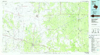 1985 Sonora1986 Print · USGSThe Edwards Plateau in the mid-1980s reveals a landscape of ranching heritage and expanding energy production. Researchers can trace the Old Railroad Grade, locate the historic Fort McKavett, and explore the extent of the Steen Gas Field.
 - 1986 Map of San Angelo
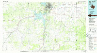 1986 San Angelo1986 Print · USGSSan Angelo and the Concho Valley appear here in the mid-1980s as a landscape shaped by massive reservoirs and a thriving energy industry. Researchers can trace the Atchison Topeka and Santa Fe rail line past Knickerbocker and explore the sprawling Oil and Gas Fields of the western plains.2 unique versions available
End of results
Showing maps 1-2 of 2
Top cities of Schleicher County
Frequently asked questions
- What are the different types of historical maps available for Schleicher County?
- What is the oldest map of Schleicher County?
- Where can I purchase historical maps of Schleicher County for my home or office?
- Where can I download high-res historical maps of Schleicher County?
- Are there historical topographic maps available for Schleicher County?
- Is there historical aerial imagery available for Schleicher County?
- Where are historical maps of Schleicher County sourced from?