1960s Maps of Scurry County, Texas
Explore 9 historic maps of Scurry County from the 1960s. These maps offer a rare glimpse into what life looked like during the 1960s — showing old roads, neighborhoods, homes, and landmarks that have changed or disappeared over time.
Whether you're researching your family's past, planning a metal detecting trip, or studying how Scurry County's landscape evolved across the 1960s, these high-resolution maps are a powerful tool for exploring the history of this region.
- Focus on a specific era: All maps on this page are from the 1960s, giving you a focused view of this time period.
- See what’s changed: Compare century-old streets, trails, and buildings to today's modern landscape using overlays and satellite layers.
- Research with precision: Use these maps for genealogy, historical research, land use analysis, or educational projects.
- View, download, or print: Maps are fully viewable online in high resolution, and can be downloaded or printed for your own records.
Start exploring Scurry County's history through authentic maps from the 1960s. This is your window into the past.
Scurry County, TX maps
(9)- 1969 Map of Arah, 1971 Print
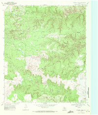
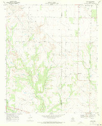 1969 Arah1971 Print · USGSThe borderlands of Borden and Scurry Counties are captured here in the late sixties, showing a landscape of ranching and early oil exploration. Genealogists can trace the Fluvanna Cem and York Cem or locate the small settlement of Arah.
 - 1969 Map of Fluvanna, 1971 Print
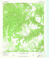
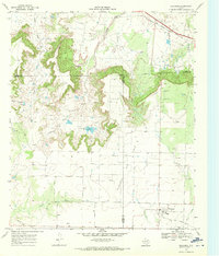 1969 Fluvanna1971 Print · USGSFluvanna and the high plains of Scurry and Borden counties are captured here in the late sixties as the local oil industry flourished. Researchers can trace the legacy of the Atchison Topeka and Santa Fe and locate the Fluvanna Cem near the Old Railroad Grade.
 - 1969 Map of Camp Springs, 1972 Print
 1969 Camp Springs1972 Print · USGSThe ranching and oil country of the Scurry and Fisher county line is documented here in the late sixties. Researchers can trace family history at Camp Springs Cem or locate early water sources like Dripping Spring and Spring Creek.
 - 1969 Map of Inadale NW, 1972 Print
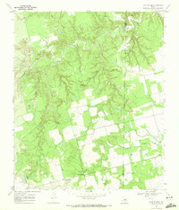
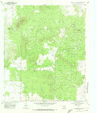
 1969 Inadale NW1972 Print · USGSScurry County's rural landscape is captured here in the late sixties as the local economy balanced ranching with utility infrastructure. Genealogists and researchers can locate the Hermleigh Cem or trace the path of the Clear Fork Brazos River and the Snyder Rotan Aqueduct.
 - 1969 Map of Maverick Creek, 1972 Print
 1969 Maverick Creek1972 Print · USGSThe Scurry and Kent County line area comes into focus during the late sixties, highlighting the industrial expansion of the Cogdell Oil Field. Local researchers can trace old energy infrastructure and landmarks like Church Peak, Criswell, and the Pumping Sta.
 - 1969 Map of Hudd, 1972 Print
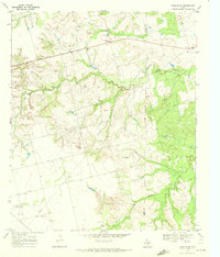
 1969 Hudd1972 Print · USGSScurry County ranching and river breaks are documented here in the late sixties, showing the transition from canyonlands to agricultural flats. Researchers can locate the Cottonwood Flat Cem, Criswell Ranch, and landmarks like Sugar Loaf.
 - 1969 Map of Flat Top Mountain, 1972 Print
 1969 Flat Top Mountain1972 Print · USGSScurry County ranching and petroleum fields are shown here in the late sixties, where the railroad meets the rugged hills. You can trace family operations at Williams Ranch or locate rail stops along the Atchison Topeka and Santa Fe near Fullerville.
 - 1969 Map of McKenzie Mountains, 1972 Print
 1969 McKenzie Mountains1972 Print · USGSScurry County's petroleum landscape is captured here in the late sixties, where the industrial expansion of the Fuller Oil Field meets the Texas rangeland. Researchers can trace the layout of the Fuller Ranch, the Fuller Landing Strip, and a sprawling network of oil wells and pipelines.
 - 1969 Map of Inadale, 1973 Print
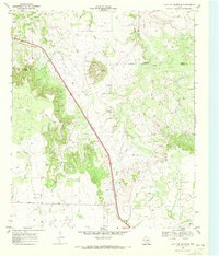
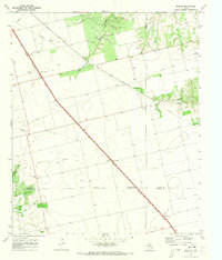 1969 Inadale1973 Print · USGSWest Texas rail junctions and agricultural boundaries are captured here in the late sixties as the region's economy relied on heavy rail transport. Trace the routes of the Roscoe Snyder and Pacific and locate family burial sites at Pyron Cem or Lone Wolf Cem.
End of results
Showing maps 1-9 of 9
Top cities of Scurry County
Frequently asked questions
- What are the different types of historical maps available for Scurry County?
- What is the oldest map of Scurry County?
- Where can I purchase historical maps of Scurry County for my home or office?
- Where can I download high-res historical maps of Scurry County?
- Are there historical topographic maps available for Scurry County?
- Is there historical aerial imagery available for Scurry County?
- Where are historical maps of Scurry County sourced from?