1900s (20th Century) Maps of Stephens County, Texas
Explore 28 historic maps of Stephens County from the 1900s (20th Century). These maps offer a rare glimpse into what life looked like during the 1900s — showing old roads, neighborhoods, homes, and landmarks that have changed or disappeared over time.
Whether you're researching your family's past, planning a metal detecting trip, or studying how Stephens County's landscape evolved across the 1900s, these high-resolution maps are a powerful tool for exploring the history of this region.
- Focus on a specific era: All maps on this page are from the 1900s, giving you a focused view of this time period.
- See what’s changed: Compare century-old streets, trails, and buildings to today's modern landscape using overlays and satellite layers.
- Research with precision: Use these maps for genealogy, historical research, land use analysis, or educational projects.
- View, download, or print: Maps are fully viewable online in high resolution, and can be downloaded or printed for your own records.
Start exploring Stephens County's history through authentic maps from the 1900s. This is your window into the past.
Stephens County, TX maps
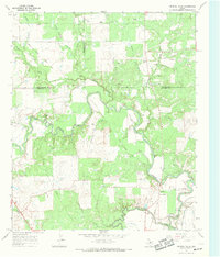
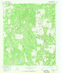
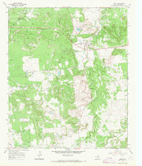
(28)- 1924 Map of Breckenridge 1-a
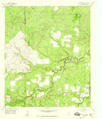
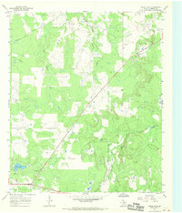
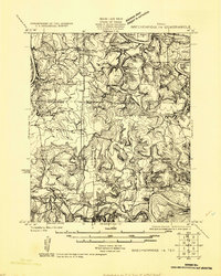 1924 Breckenridge 1-a1924 Print · USGSNorth Central Texas oil and ranching lands are captured here in the mid-1920s at the junction of three counties. Genealogists can locate family homesteads near Eliasville PO, Sorghum Flat School, or the petroleum derricks at Eubanks Derrick.
 - 1924 Map of Breckenridge 1-d
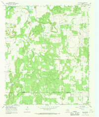
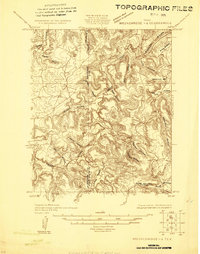 1924 Breckenridge 1-d1924 Print · USGSThe borderlands of Stephens and Palo Pinto counties are captured here in the mid-1920s, showing a rugged landscape of winding creek beds and family-named hollows. Genealogists and researchers can locate old landmarks like Cedar Springs Church, Hayrick Mt, and Hog Bend.
 - 1925 Map of Breckenridge 1-b
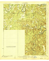
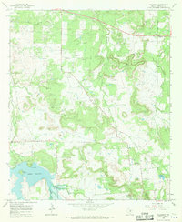
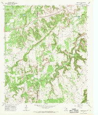
 1925 Breckenridge 1-b1925 Print · USGSThe Brazos River valley at the Stephens and Young county line comes to life in this mid-1920s survey. Genealogists and local historians can trace the rural landscape through the locations of Lone Star School, the settlement of Ivan, and the Wichita Southern rail line.
 - 1931 Map of Ivan
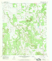
 1931 Ivan1931 Print · USGSThe Brazos River loop and the rolling breaks of north-central Texas are captured here in the mid-1920s. Genealogists can locate family-named schoolhouses and small settlements like Duff Prairie Sch, South Bend, and Oil City.2 unique versions available
 - 1954 Map of Abilene, 1966 Print
 1954 Abilene1966 Print · USGSThe Texas Big Country comes into focus in the mid-1950s as petroleum and new water projects reshape the landscape. Local historians can trace the Butterfield Trail, find the Fort Phantom Hill Ruins, and locate numerous small communities along the Texas & Pacific line.2 unique versions available
 - 1958 Map of Abilene
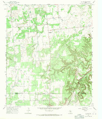
 1958 Abilene1958 Print · USGSMid-century West Texas comes alive in this survey of the Abilene and Stephenville region during a period of steady oil expansion and military growth. Genealogists and local historians can trace the paths of the Texas & Pacific RR through historic towns, locate the Fort Griffin Ruins, and find smaller settlements like Desdemona and Lueders.
 - 1958 Map of Breckenridge, 1959 Print
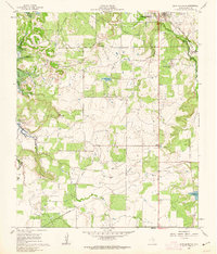
 1958 Breckenridge1959 Print · USGSBreckenridge and its surrounding oil-and-cattle country are documented here during the late fifties. Genealogists and local historians can trace the Rock Island Railroad, locate the Picketville Cem, and identify numerous Sludge Pits from the era's energy production.3 unique versions available
 - 1958 Map of Edwards Branch, 1959 Print
 1958 Edwards Branch1959 Print · USGSThe rural boundary of Shackelford and Stephens counties comes into focus in the late 1950s, highlighting a landscape shaped by ranching and the oil industry. Genealogists and historians can locate Graves and trace the paths of Hubbard Creek and The Island.3 unique versions available
 - 1961 Map of Buck Mountain, 1962 Print
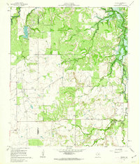
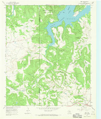
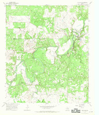
 1961 Buck Mountain1962 Print · USGSStephens County appears here in the early sixties during the construction of Hubbard Creek Lake. Genealogists and historians can trace the original landscape before flooding, locating Post Oak Cem, the Curry Oil Field, and the Chicago Rock Island and Pacific rail line.3 unique versions available
 - 1961 Map of Eolian, 1962 Print
 1961 Eolian1962 Print · USGSStephens County ranching and oil country come into focus during the early sixties, just as modern water management began reshaping the local terrain. Genealogists and researchers can locate Mankins Mill (Site), Shady Grove Ch, and the Battle Creek Cem.3 unique versions available
 - 1965 Map of Lusk, 1967 Print
 1965 Lusk1967 Print · USGSThe rural borderlands of Stephens and Throckmorton counties come into focus in the mid-1960s as the Brazos River winds through cattle and oil country. Genealogists and researchers can trace local landmarks like Lusk, numerous rural Drill Holes, and the quiet Roadside Park along the highway.
 - 1965 Map of Indian Knoll, 1967 Print
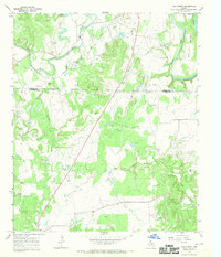
 1965 Indian Knoll1967 Print · USGSThe West Texas rangelands at the crossroads of Stephens and Eastland counties come into focus in the mid-1960s. Genealogists and researchers can trace family-named sites like Graves and explore the industrial footprint of Eureka and the Compressor Sta.
 - 1967 Map of Crystal Falls, 1969 Print
 1967 Crystal Falls1969 Print · USGSCrystal Falls and the winding river valleys of North Central Texas are captured here in the late sixties. Researchers can trace family history through several rural burial sites like Stoker Cem and Snake Den Cem or follow the path of the Chicago Rock Island and Pacific Railroad.
 - 1967 Map of Wayland, 1970 Print
 1967 Wayland1970 Print · USGSStephens County ranchlands and the small community of Wayland are captured here in the late sixties as the local landscape transitioned. Researchers can trace the Old Railroad Grade and locate family names at Acker Cem or Gunsight Cem.2 unique versions available
 - 1967 Map of Necessity, 1970 Print
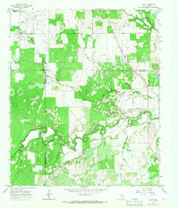
 1967 Necessity1970 Print · USGSStephens County, Texas, was undergoing a shift toward recreation and resource extraction in the late sixties as new reservoirs reshaped the land. Genealogists and researchers can locate Saints Rest Cem, trace the Old RR Grade, and find the rural community of Necessity.
 - 1967 Map of Harpersville, 1970 Print
 1967 Harpersville1970 Print · USGSStephens County ranching and oil country are mapped here in the late sixties. Genealogists and historians can trace local family landmarks like Harpersville Cem, the site of Little Flock Ch, and an Old Railroad Grade.2 unique versions available
 - 1967 Map of Grand Lake, 1970 Print
 1967 Grand Lake1970 Print · USGSThe ranchlands of Stephens County are shown in the late 1960s, a period defined by active petroleum extraction and rural land management. Researchers can locate family landmarks like Moon Cem or trace the drainage of Bufford Creek and Grand Lake.2 unique versions available
 - 1967 Map of Brad, 1970 Print
 1967 Brad1970 Print · USGSThe Palo Pinto back-country in the late sixties reveals a landscape shaped by petroleum and the waters of the Brazos. Researchers can locate the small settlement of Brad, the Cedar Springs Ch, and the industrial footprint of the Les Oil Field.2 unique versions available
 - 1967 Map of Cove Creek, 1970 Print
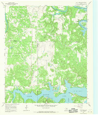 1967 Cove Creek1970 Print · USGSThe Brazos River country in the late 1960s reveals a landscape of deep river bends and the developing shoreline of Possum Kingdom Lake. Researchers can trace old family burial grounds like Mountain Home Cem and Ming Bend Cem or locate early recreation spots at Sandy Beach.2 unique versions available
 - 1967 Map of Ivan North, 1970 Print
 1967 Ivan North1970 Print · USGSYoung and Stephens Counties in the late sixties were centers of rural industry and small-town Texas life. Researchers can locate family burial sites like Hill Cem and South Bend Cem or trace the Chicago Rock Island and Pacific railroad line.
 - 1967 Map of Ivan South, 1970 Print
 1967 Ivan South1970 Print · USGSStephens County in the late 1960s reveals a landscape shaped by petroleum extraction and rugged topography. Researchers can trace the rural community of Ivan and find local landmarks like Oak Grove Ch, Bee Branch Cem, and numerous Oil Wells.
 - 1967 Map of Caddo NE, 1970 Print
 1967 Caddo NE1970 Print · USGSNorthwest Palo Pinto County shows a landscape of sharp ridges and deep draws in the late 1960s. Researchers can trace the mid-century oil industry through numerous Oil Wells and a major Pipeline near Lone Star Lake.
 - 1967 Map of Eliasville, 1970 Print
 1967 Eliasville1970 Print · USGSStephens and Young Counties are captured here in the late sixties as the river-driven economy of North Texas evolved. Genealogists and historians can locate family burial sites at Donnell Cem and Hill Cem or trace the Humble Dam along the river.2 unique versions available
 - 1967 Map of La Casa, 1971 Print
 1967 La Casa1971 Print · USGSThe borderlands of Stephens and Eastland counties appear here in the late sixties as a busy landscape of oil production and cattle ranching. Researchers can trace the Old Railroad Grade and locate local landmarks like New Hope Ch and Mt Zion Cem.2 unique versions available
 - 1967 Map of Caddo, 1971 Print
 1967 Caddo1971 Print · USGSNorth Texas oil and ranching land is captured here in the late sixties, centered on the settlement of Caddo. Researchers can trace the Old Railroad Grade near Frankell or locate family sites at Swenson Cem and Macedonia Cem.2 unique versions available
Showing maps 1-25 of 28
Top cities of Stephens County
Frequently asked questions
- What are the different types of historical maps available for Stephens County?
- What is the oldest map of Stephens County?
- Where can I purchase historical maps of Stephens County for my home or office?
- Where can I download high-res historical maps of Stephens County?
- Are there historical topographic maps available for Stephens County?
- Is there historical aerial imagery available for Stephens County?
- Where are historical maps of Stephens County sourced from?