1980s Maps of Merkel, Texas
Explore 4 historic maps of Merkel from the 1980s. These maps offer a rare glimpse into what life looked like during the 1980s — showing old roads, neighborhoods, homes, and landmarks that have changed or disappeared over time.
Whether you're researching your family's past, planning a metal detecting trip, or studying how Merkel's landscape evolved across the 1980s, these high-resolution maps are a powerful tool for exploring the history of this region.
- Focus on a specific era: All maps on this page are from the 1980s, giving you a focused view of this time period.
- See what’s changed: Compare century-old streets, trails, and buildings to today's modern landscape using overlays and satellite layers.
- Research with precision: Use these maps for genealogy, historical research, land use analysis, or educational projects.
- View, download, or print: Maps are fully viewable online in high resolution, and can be downloaded or printed for your own records.
Start exploring Merkel's history through authentic maps from the 1980s. This is your window into the past.
Merkel, TX maps
(4)- 1984 Map of Merkel West
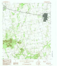 1984 Merkel West1984 Print · USGSWest Texas ranching and oil infrastructure meet in the late 1970s between the settlements of Merkel and Trent. Trace the rugged elevations of Blowout Mountain and the winding path of Mulberry Canyon alongside landmarks like Rodeo Dr.
 - 1984 Map of Merkel East
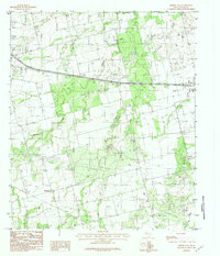 1984 Merkel East1984 Print · USGSTaylor County during the late seventies and early eighties shows a landscape of growing towns and prairie ranching. Trace local history through family-named sites like Cozart and Mt Pleasant, or locate industrial landmarks including the Oil Field and Military Reservation.2 unique versions available
 - 1985 Map of Sweetwater
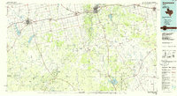 1985 Sweetwater1985 Print · USGSNolan County and the surrounding ranchlands are shown during the mid-eighties as the local economy balanced rail transport and energy production. Researchers can trace the path of the Missouri Pacific RR through Roscoe or locate rural landmarks like Ft Chadbourne and the Bauman School.2 unique versions available
 - 1985 Map of Abilene, 1986 Print
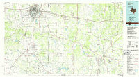 1985 Abilene1986 Print · USGSThe West Texas ranching and rail landscape around Abilene is captured here in the mid-1980s. Local researchers can trace the growth of Hardin-Simmons University, locate family sites near Ross Cem, or explore the area around Buffalo Gap and Dyess Air Force Base.2 unique versions available
End of results
Showing maps 1-4 of 4
Top cities near Merkel
- Abilene historical maps
- Tye historical maps
- Hawley historical maps
- Buffalo Gap historical maps
- Trent historical maps
Frequently asked questions
- What are the different types of historical maps available for Merkel?
- What is the oldest map of Merkel?
- Where can I purchase historical maps of Merkel for my home or office?
- Where can I download high-res historical maps of Merkel?
- Are there historical topographic maps available for Merkel?
- Is there historical aerial imagery available for Merkel?
- Where are historical maps of Merkel sourced from?