1980s Maps of Throckmorton County, Texas
Explore 4 historic maps of Throckmorton County from the 1980s. These maps offer a rare glimpse into what life looked like during the 1980s — showing old roads, neighborhoods, homes, and landmarks that have changed or disappeared over time.
Whether you're researching your family's past, planning a metal detecting trip, or studying how Throckmorton County's landscape evolved across the 1980s, these high-resolution maps are a powerful tool for exploring the history of this region.
- Focus on a specific era: All maps on this page are from the 1980s, giving you a focused view of this time period.
- See what’s changed: Compare century-old streets, trails, and buildings to today's modern landscape using overlays and satellite layers.
- Research with precision: Use these maps for genealogy, historical research, land use analysis, or educational projects.
- View, download, or print: Maps are fully viewable online in high resolution, and can be downloaded or printed for your own records.
Start exploring Throckmorton County's history through authentic maps from the 1980s. This is your window into the past.
Throckmorton County, TX maps
(4)- 1985 Map of Graham
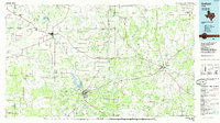 1985 Graham1985 Print · USGSNorth Texas in the mid-eighties shows a landscape of growing reservoirs and historic cattle country. Genealogists and historians can trace the foundations of Young County through the Belknap Mountains, Barton Chapel, and the grounds of Fort Richardson State Park.2 unique versions available
 - 1985 Map of Haskell
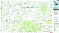 1985 Haskell1985 Print · USGSIn the mid-eighties, this West Texas region highlights a robust agricultural and petroleum economy centered on Haskell and Throckmorton. Trace rail history along the Burlington Northern or locate family roots near Goree and Throckmorton Cem.2 unique versions available
 - 1985 Map of Mineral Wells
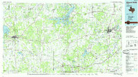 1985 Mineral Wells1985 Print · USGSNorth-central Texas in the mid-eighties shows a landscape of deep river valleys and massive reservoirs. Genealogists and historians can trace the Missouri Pacific rail line and locate rural settlements like Thurber, Necessity, and Palo Pinto.2 unique versions available
 - 1985 Map of Stamford, 1992 Print
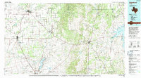 1985 Stamford1992 Print · USGSMid-century West Texas comes alive in this survey of the Brazos River country, showing a landscape defined by oil production and rail transport. Researchers can locate family landmarks like the Avoca Sch, New Hope Ch, and the frontier history at Fort Griffin State Park.
End of results
Showing maps 1-4 of 4
Top cities of Throckmorton County
Frequently asked questions
- What are the different types of historical maps available for Throckmorton County?
- What is the oldest map of Throckmorton County?
- Where can I purchase historical maps of Throckmorton County for my home or office?
- Where can I download high-res historical maps of Throckmorton County?
- Are there historical topographic maps available for Throckmorton County?
- Is there historical aerial imagery available for Throckmorton County?
- Where are historical maps of Throckmorton County sourced from?