1980s Maps of San Angelo, Texas
Explore 6 historic maps of San Angelo from the 1980s. These maps offer a rare glimpse into what life looked like during the 1980s — showing old roads, neighborhoods, homes, and landmarks that have changed or disappeared over time.
Whether you're researching your family's past, planning a metal detecting trip, or studying how San Angelo's landscape evolved across the 1980s, these high-resolution maps are a powerful tool for exploring the history of this region.
- Focus on a specific era: All maps on this page are from the 1980s, giving you a focused view of this time period.
- See what’s changed: Compare century-old streets, trails, and buildings to today's modern landscape using overlays and satellite layers.
- Research with precision: Use these maps for genealogy, historical research, land use analysis, or educational projects.
- View, download, or print: Maps are fully viewable online in high resolution, and can be downloaded or printed for your own records.
Start exploring San Angelo's history through authentic maps from the 1980s. This is your window into the past.
San Angelo, TX maps
(6)- 1984 Map of Veribest
 1984 Veribest1984 Print · USGSThe rural community of Veribest and the productive acreage of the Lipan Flat are captured here during the mid-seventies. Local historians can trace the vital irrigation systems of the Main Canal and the natural path of the Concho River.
 - 1984 Map of Pecan Station
 1984 Pecan Station1984 Print · USGSTom Green County in the mid-1980s shows a landscape shaped by river systems and aviation. Genealogists and historians can trace the topography of Lipan Flat, find the local Pecan Station, and locate landmarks like Mathis Field.
 - 1984 Map of Knickerbocker
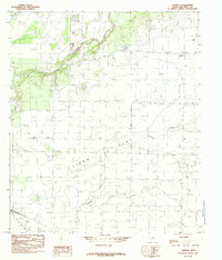
 1984 Knickerbocker1984 Print · USGSTom Green County was navigating a period of hydraulic and aerial expansion in the early eighties. Genealogists and historians can trace the Knickerbocker settlement and its Cem alongside landmarks like Mathis Field and Twin Buttes Reservoir.
 - 1984 Map of Harriet
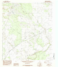 1984 Harriet1984 Print · USGSThe rural landscape of Tom Green County during the mid-eighties shows a world of ranchland and river drainages. Genealogists and researchers can trace the vicinity of Harriet and landmarks like Rattle Snake Hill, the Test Facility, and the banks of the Concho River.
 - 1986 Map of San Angelo
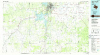 1986 San Angelo1986 Print · USGSSan Angelo and the Concho Valley appear here in the mid-1980s as a landscape shaped by massive reservoirs and a thriving energy industry. Researchers can trace the Atchison Topeka and Santa Fe rail line past Knickerbocker and explore the sprawling Oil and Gas Fields of the western plains.2 unique versions available
 - 1986 Map of Robert Lee
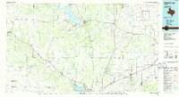 1986 Robert Lee1986 Print · USGSWest Texas ranching and oil country come into focus in the mid-eighties as the E V Spence Reservoir reshapes the landscape near Robert Lee. Researchers can trace the path of the Atchison Topeka and Santa Fe railroad through Rowena or locate the historic Fort Chadbourne.2 unique versions available
End of results
Showing maps 1-6 of 6
Top cities near San Angelo
Top neighborhoods of San Angelo
- Alvery Junction historical maps
- Belaire historical maps
- Bentwood historical maps
- Butler Farms historical maps
- Central historical maps
- Riverside historical maps
See more
Frequently asked questions
- What are the different types of historical maps available for San Angelo?
- What is the oldest map of San Angelo?
- Where can I purchase historical maps of San Angelo for my home or office?
- Where can I download high-res historical maps of San Angelo?
- Are there historical topographic maps available for San Angelo?
- Is there historical aerial imagery available for San Angelo?
- Where are historical maps of San Angelo sourced from?