1930s Maps of Austin, Texas
Explore 2 historic maps of Austin from the 1930s. These maps offer a rare glimpse into what life looked like during the 1930s — showing old roads, neighborhoods, homes, and landmarks that have changed or disappeared over time.
Whether you're researching your family's past, planning a metal detecting trip, or studying how Austin's landscape evolved across the 1930s, these high-resolution maps are a powerful tool for exploring the history of this region.
- Focus on a specific era: All maps on this page are from the 1930s, giving you a focused view of this time period.
- See what’s changed: Compare century-old streets, trails, and buildings to today's modern landscape using overlays and satellite layers.
- Research with precision: Use these maps for genealogy, historical research, land use analysis, or educational projects.
- View, download, or print: Maps are fully viewable online in high resolution, and can be downloaded or printed for your own records.
Start exploring Austin's history through authentic maps from the 1930s. This is your window into the past.
Austin, TX maps
(2)- 1930 Map of Austin-2
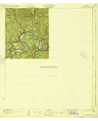
 1930 Austin-21930 Print · USGSThe winding loops of the Colorado River dominate this 1930 survey of Travis County before the era of major dams. Researchers can trace early crossings like Stewart Ford and locate local landmarks such as the Jack Sch and Ch.
 - 1932 Map of Mt. Bonnell
 1932 Mt. Bonnell1932 Print · USGSThe meanders of the Texas Hill Country are captured here in the early 1930s, just before the landscape was transformed by dam construction. You can trace early river life through multiple historical crossings like Lohmann Ford and rural sites like Cox Spring Sch.2 unique versions available
End of results
Showing maps 1-2 of 2
Top cities near Austin
- Round Rock historical maps
- Pflugerville historical maps
- Cedar Park historical maps
- Hutto historical maps
- Leander historical maps
- Lakeway historical maps
See more
Top neighborhoods of Austin
- Sprinkle Corner historical maps
- Jollyville historical maps
- Avery Ranch historical maps
- Windsor Park historical maps
- Bouldin historical maps
- Broadacres historical maps
See more
Frequently asked questions
- What are the different types of historical maps available for Austin?
- What is the oldest map of Austin?
- Where can I purchase historical maps of Austin for my home or office?
- Where can I download high-res historical maps of Austin?
- Are there historical topographic maps available for Austin?
- Is there historical aerial imagery available for Austin?
- Where are historical maps of Austin sourced from?