Old Maps of Briarcliff, Texas for Genealogy
Trace your family roots with 14 historic maps of Briarcliff. These high-res maps reveal old neighborhoods, homesites, landmarks, and streets — helping you uncover where your ancestors lived and how the area evolved over time.
- Explore historic neighborhoods: Identify where your relatives may have lived in the 1800s or 1900s.
- Compare maps over time: Trace the changes in streets, buildings, and landmarks for multi-generational research.
- Perfect for genealogy & ancestry research: Used by family historians and researchers to map out lineage and migration.
These maps are an incredible resource for exploring your personal connection to Briarcliff's past.
Briarcliff, TX maps
(14)- 1887 Map of Blanco
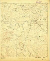 1887 Blanco1887 Print · USGSCentral Texas at the dawn of the Hill Country's development, when early ranching life centered on river fords and spring-fed creeks. Trace the paths between Johnson City, Blanco, and Dripping Springs, or locate landmarks like Jacob's Well and Dead Mans Hole.
 - 1894 Map of Blanco
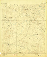 1894 Blanco1894 Print · USGSThe Texas Hill Country comes into focus during the late frontier era, centered on the newly established Johnson City and Blanco. Genealogists can trace early homesteads and communities near Jacobs Well, Dripping Springs, and the isolated Cypress Mill.5 unique versions available
 - 1930 Map of Blanco-1
 1930 Blanco-11930 Print · USGSCentral Texas river valleys appear in high detail during the early 1930s, showing the landscape before later reservoir projects. Trace the original paths of the Colorado River and Pedernales River past Pleasant Grove Sch and Buggy Ford.
 - 1954 Map of Llano, 1964 Print
 1954 Llano1964 Print · USGSThe Texas Hill Country and Highland Lakes appear in the mid-fifties, just as new reservoirs began reshaping the landscape. Trace ranching history and river routes from Mason to Llano, or follow the Gulf Colorado and Santa Fe RR past Buchanan Lake.2 unique versions available
 - 1955 Map of Llano
 1955 Llano1955 Print · USGSCentral Texas and the Hill Country are seen here during the mid-1950s growth of the Highland Lakes. Trace old settlements and geologic landmarks from Enchanted Rock and Longhorn Cavern to the small community of Luckenbach.
 - 1956 Map of Llano, 1976 Print
 1956 Llano1976 Print · USGSThe Texas Hill Country comes alive in this mid-seventies survey of the Llano Uplift and Colorado River lakes. Genealogists and historians can trace family roots through settlements like Luckenbach and Castell or locate the famed L B J Ranch and Enchanted Rock.
 - 1967 Map of Pace Bend, 1969 Print
 1967 Pace Bend1969 Print · USGSLake Travis and the Colorado River meander through Travis and Burnet Counties in the late sixties as the shoreline began its modern transformation. Genealogists can locate family landmarks like Fall Creek Cem and the traces of Old Ferry Road.2 unique versions available
 - 1985 Map of Pedernales River
 1985 Pedernales River1985 Print · USGSThe Texas Hill Country comes alive in the mid-1980s, documenting a landscape of ranching roots and presidential history. Researchers can trace historic settlements like Luckenbach, the presidential grounds of Lyndon B. Johnson National Historic Park, and the early rail path of the Southern Pacific Railroad.2 unique versions available
 - 1986 Map of Pace Bend
 1986 Pace Bend1986 Print · USGSThe Hill Country terrain of Travis and Burnet counties is captured here in the mid-eighties as the waters of Lake Travis shaped the local economy. Researchers can trace land use through Haynie Flats Cem, the Old Ferry Road, and numerous shoreline landmarks like Muleshoe Bend.2 unique versions available
 - 2010 Map of Pace Bend, 2010 Print
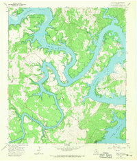
 2010 Pace Bend2010 Print · USGSCovers Briarcliff, including Lakeway, Lago Vista, and other nearby areas
 - 2012 Map of Pace Bend, 2012 Print
 2012 Pace Bend2012 Print · USGSCovers Briarcliff, including Lakeway, Lago Vista, and other nearby areas
 - 2016 Map of Pace Bend, 2016 Print
 2016 Pace Bend2016 Print · USGSCovers Briarcliff, including Lakeway, Lago Vista, and other nearby areas
 - 2019 Map of Pace Bend, 2019 Print
 2019 Pace Bend2019 Print · USGSCovers Briarcliff, including Lakeway, Lago Vista, and other nearby areas
 - 2022 Map of Pace Bend, 2022 Print
 2022 Pace Bend2022 Print · USGSThe winding shores of Lake Travis and the Colorado River take center stage in this 2020s study of Travis and Burnet counties. Genealogists can locate several family burial grounds like Haynie Flat Cem and Singleton Family Cem tucked between the growing lakeside communities of Lago Vista and Briarcliff.
End of results
Showing maps 1-14 of 14
Top cities near Briarcliff
- Austin historical maps
- Georgetown historical maps
- Cedar Park historical maps
- Leander historical maps
- Lakeway historical maps
- Liberty Hill historical maps
See more
Frequently asked questions
- What are the different types of historical maps available for Briarcliff?
- What is the oldest map of Briarcliff?
- Where can I purchase historical maps of Briarcliff for my home or office?
- Where can I download high-res historical maps of Briarcliff?
- Are there historical topographic maps available for Briarcliff?
- Is there historical aerial imagery available for Briarcliff?
- Where are historical maps of Briarcliff sourced from?