1960s Maps of Tyler County, Texas
Explore 2 historic maps of Tyler County from the 1960s. These maps offer a rare glimpse into what life looked like during the 1960s — showing old roads, neighborhoods, homes, and landmarks that have changed or disappeared over time.
Whether you're researching your family's past, planning a metal detecting trip, or studying how Tyler County's landscape evolved across the 1960s, these high-resolution maps are a powerful tool for exploring the history of this region.
- Focus on a specific era: All maps on this page are from the 1960s, giving you a focused view of this time period.
- See what’s changed: Compare century-old streets, trails, and buildings to today's modern landscape using overlays and satellite layers.
- Research with precision: Use these maps for genealogy, historical research, land use analysis, or educational projects.
- View, download, or print: Maps are fully viewable online in high resolution, and can be downloaded or printed for your own records.
Start exploring Tyler County's history through authentic maps from the 1960s. This is your window into the past.
Tyler County, TX maps
(2)- 1963 Map of Wolf Hill, 1966 Print
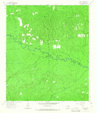 1963 Wolf Hill1966 Print · USGSDeep in the Piney Woods during the early sixties, the Neches River valley reveals a landscape of family-run cemeteries and old timber routes. Trace the Old Railroad Grade and find historic sites like Lambert Chapel or the Wolf Hill Lookout Tower.2 unique versions available
 - 1963 Map of Pluck, 1966 Print
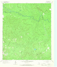 1963 Pluck1966 Print · USGSThe bottomlands of the Neches River are captured here in the early sixties, showing a landscape defined by timber-era infrastructure and rural outposts. Genealogists can locate Grimes Cem and Stryker Cem while tracing the Old Railroad Grade near Pluck.2 unique versions available
End of results
Showing maps 1-2 of 2
Top cities of Tyler County
Frequently asked questions
- What are the different types of historical maps available for Tyler County?
- What is the oldest map of Tyler County?
- Where can I purchase historical maps of Tyler County for my home or office?
- Where can I download high-res historical maps of Tyler County?
- Are there historical topographic maps available for Tyler County?
- Is there historical aerial imagery available for Tyler County?
- Where are historical maps of Tyler County sourced from?