1900s (20th Century) Maps of Lake Amistad, Texas
Explore 6 historic maps of Lake Amistad from the 1900s (20th Century). These maps offer a rare glimpse into what life looked like during the 1900s — showing old roads, neighborhoods, homes, and landmarks that have changed or disappeared over time.
Whether you're researching your family's past, planning a metal detecting trip, or studying how Lake Amistad's landscape evolved across the 1900s, these high-resolution maps are a powerful tool for exploring the history of this region.
- Focus on a specific era: All maps on this page are from the 1900s, giving you a focused view of this time period.
- See what’s changed: Compare century-old streets, trails, and buildings to today's modern landscape using overlays and satellite layers.
- Research with precision: Use these maps for genealogy, historical research, land use analysis, or educational projects.
- View, download, or print: Maps are fully viewable online in high resolution, and can be downloaded or printed for your own records.
Start exploring Lake Amistad's history through authentic maps from the 1900s. This is your window into the past.
Lake Amistad, TX maps
(6)- 1943 Map of Devils River, 1958 Print
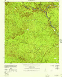 1943 Devils River1958 Print · USGSVal Verde County during the Second World War was a land of sprawling ranch estates and vital international river crossings along the border. Local historians can trace family landholdings like Jones Ranch and locate early infrastructure such as the C P & L Co Steam Plant and the railroad stop at McKees.2 unique versions available
 - 1944 Map of Devils River
 1944 Devils River1944 Print · USGSThe Texas-Mexico border landscape comes to life in the mid-1940s, documenting the vital river crossings and early power infrastructure of the region. Local researchers can trace family lands like the H G Nixon Ranch and explore early industrial sites including the Devils River Steam Plant.
 - 1958 Map of Del Rio, 1970 Print
 1958 Del Rio1970 Print · USGSThe Texas-Mexico borderlands come alive in the late fifties, showing the confluence of the Rio Grande and the emerging Amistad Reservoir. Trace the lineage of the Southern Pacific rail line through stops at Pumpville, Shumla, and the mining vicinity of Blewett.2 unique versions available
 - 1964 Map of Del Rio
 1964 Del Rio1964 Print · USGSAlong the Mexican border during the mid-sixties, this area centered on the confluence of the Rio Grande and Devils River. Researchers can trace the Southern Pacific line through isolated stops like Pumpville or locate military and industrial sites such as Laughlin Air Force Base and the mines at Blewett.
 - 1972 Map of Amistad Dam, 1975 Print
 1972 Amistad Dam1975 Print · USGSThe Texas-Mexico border underwent a massive transformation in the early seventies following the impoundment of the Amistad Reservoir. Genealogists and historians can trace the new shoreline and infrastructure around Amistad Dam, Amistad Village, and the Southern Pacific rail line.
 - 1985 Map of Amistad Village
 1985 Amistad Village1985 Print · USGSThe Texas-Mexico borderlands in the mid-eighties show a landscape defined by massive water management and international transit. Trace the impact of the Amistad Reservoir on the local terrain, locating the Amistad Dam, the Southern Pacific line, and Amistad Village.2 unique versions available
End of results
Showing maps 1-6 of 6
Top cities near Lake Amistad
Frequently asked questions
- What are the different types of historical maps available for Lake Amistad?
- What is the oldest map of Lake Amistad?
- Where can I purchase historical maps of Lake Amistad for my home or office?
- Where can I download high-res historical maps of Lake Amistad?
- Are there historical topographic maps available for Lake Amistad?
- Is there historical aerial imagery available for Lake Amistad?
- Where are historical maps of Lake Amistad sourced from?