Old Maps of Lake Amistad, Texas for Hiking & Exploration
Hike through history with 11 historic maps of Lake Amistad. Explore old trails, ghost towns, and forgotten backroads — perfect for outdoor adventurers and local explorers.
- Rediscover forgotten places: Map out old mining camps, roads, and footpaths that no longer exist on modern maps.
- Layer with modern tools: Combine with LiDAR or satellite views to plan hikes through historical terrain.
- Made for exploration: Popular among hikers, overlanders, and local history lovers.
Use these maps to find adventure and explore the hidden past of Lake Amistad.
Lake Amistad, TX maps
(11)- 1943 Map of Devils River, 1958 Print
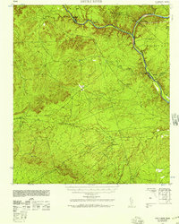 1943 Devils River1958 Print · USGSVal Verde County during the Second World War was a land of sprawling ranch estates and vital international river crossings along the border. Local historians can trace family landholdings like Jones Ranch and locate early infrastructure such as the C P & L Co Steam Plant and the railroad stop at McKees.2 unique versions available
 - 1944 Map of Devils River
 1944 Devils River1944 Print · USGSThe Texas-Mexico border landscape comes to life in the mid-1940s, documenting the vital river crossings and early power infrastructure of the region. Local researchers can trace family lands like the H G Nixon Ranch and explore early industrial sites including the Devils River Steam Plant.
 - 1958 Map of Del Rio, 1970 Print
 1958 Del Rio1970 Print · USGSThe Texas-Mexico borderlands come alive in the late fifties, showing the confluence of the Rio Grande and the emerging Amistad Reservoir. Trace the lineage of the Southern Pacific rail line through stops at Pumpville, Shumla, and the mining vicinity of Blewett.2 unique versions available
 - 1964 Map of Del Rio
 1964 Del Rio1964 Print · USGSAlong the Mexican border during the mid-sixties, this area centered on the confluence of the Rio Grande and Devils River. Researchers can trace the Southern Pacific line through isolated stops like Pumpville or locate military and industrial sites such as Laughlin Air Force Base and the mines at Blewett.
 - 1972 Map of Amistad Dam, 1975 Print
 1972 Amistad Dam1975 Print · USGSThe Texas-Mexico border underwent a massive transformation in the early seventies following the impoundment of the Amistad Reservoir. Genealogists and historians can trace the new shoreline and infrastructure around Amistad Dam, Amistad Village, and the Southern Pacific rail line.
 - 1985 Map of Amistad Village
 1985 Amistad Village1985 Print · USGSThe Texas-Mexico borderlands in the mid-eighties show a landscape defined by massive water management and international transit. Trace the impact of the Amistad Reservoir on the local terrain, locating the Amistad Dam, the Southern Pacific line, and Amistad Village.2 unique versions available
 - 2010 Map of Amistad Dam, 2010 Print
 2010 Amistad Dam2010 Print · USGSCovers Lake Amistad, including Amistad Village, Acuña, and other nearby areas
 - 2013 Map of Amistad Dam, 2013 Print
 2013 Amistad Dam2013 Print · USGSCovers Lake Amistad, including Amistad Village, Acuña, and other nearby areas
 - 2016 Map of Amistad Dam, 2016 Print
 2016 Amistad Dam2016 Print · USGSCovers Lake Amistad, including Amistad Village, Acuña, and other nearby areas
 - 2019 Map of Amistad Dam, 2019 Print
 2019 Amistad Dam2019 Print · USGSCovers Lake Amistad, including Amistad Village, Acuña, and other nearby areas
 - 2022 Map of Amistad Dam, 2022 Print
 2022 Amistad Dam2022 Print · USGSThe international border along the Rio Grande is documented here as it appeared in the early 2020s. Researchers can trace the modern development of the Amistad National Recreation Area and locate local landmarks like McKee Springs and Salems Point.
End of results
Showing maps 1-11 of 11
Top cities near Lake Amistad
Frequently asked questions
- What are the different types of historical maps available for Lake Amistad?
- What is the oldest map of Lake Amistad?
- Where can I purchase historical maps of Lake Amistad for my home or office?
- Where can I download high-res historical maps of Lake Amistad?
- Are there historical topographic maps available for Lake Amistad?
- Is there historical aerial imagery available for Lake Amistad?
- Where are historical maps of Lake Amistad sourced from?