Old Maps of Lake View, Texas for Metal Detecting
Plan your next treasure hunt with 10 historic maps of Lake View. Find old homesites, ghost towns, trails, and gathering spots that may be lost to time — perfect for identifying promising metal detecting locations.
- Locate forgotten sites: Uncover places like long-lost settlements, abandoned rail lines, or gathering spots.
- Plan better hunts: Use map overlays combined with LiDAR or satellite views to narrow in on historically rich areas.
- Made for detectorists: Thousands of hobbyists use these maps to discover relics, coins, and hidden history.
Use these historic maps to boost your research and find new opportunities beneath the surface of Lake View.
Lake View, TX maps
(10)- 1943 Map of Del Rio, 1969 Print
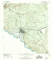 1943 Del Rio1969 Print · USGSDel Rio and the Rio Grande borderlands are captured here during the mobilization of the early 1940s. Researchers can trace family ranching history at Brite Ranch or locate the burgeoning military operations at Laughlin Field.
 - 1958 Map of Del Rio, 1970 Print
 1958 Del Rio1970 Print · USGSThe Texas-Mexico borderlands come alive in the late fifties, showing the confluence of the Rio Grande and the emerging Amistad Reservoir. Trace the lineage of the Southern Pacific rail line through stops at Pumpville, Shumla, and the mining vicinity of Blewett.2 unique versions available
 - 1964 Map of Del Rio
 1964 Del Rio1964 Print · USGSAlong the Mexican border during the mid-sixties, this area centered on the confluence of the Rio Grande and Devils River. Researchers can trace the Southern Pacific line through isolated stops like Pumpville or locate military and industrial sites such as Laughlin Air Force Base and the mines at Blewett.
 - 1972 Map of Del Rio NW, 1975 Print
 1972 Del Rio NW1975 Print · USGSDel Rio and the neighboring settlement of Cantu are captured in the early 1970s just as the newly formed Amistad Reservoir reshaped the local landscape. Genealogists and historians can locate specific properties along Bedell Ave or trace landmarks like Val Verde Memorial Hospital and the Fish Hatchery.
 - 1986 Map of Del Rio
 1986 Del Rio1986 Print · USGSThe West Texas borderlands come alive in the mid-eighties as Del Rio expands and Laughlin AFB anchors the local economy. Researchers can trace the rail corridors through Spofford and Cline or locate family sites near Alamo Village.2 unique versions available
 - 2010 Map of Del Rio NW, 2010 Print
 2010 Del Rio NW2010 Print · USGSCovers Lake View, including Del Rio, Lake View Addition Colonia, and other nearby areas
 - 2013 Map of Del Rio NW, 2013 Print
 2013 Del Rio NW2013 Print · USGSCovers Lake View, including Del Rio, Lake View Addition Colonia, and other nearby areas
 - 2016 Map of Del Rio NW, 2016 Print
 2016 Del Rio NW2016 Print · USGSCovers Lake View, including Del Rio, Lake View Addition Colonia, and other nearby areas
 - 2019 Map of Del Rio NW, 2019 Print
 2019 Del Rio NW2019 Print · USGSCovers Lake View, including Del Rio, Lake View Addition Colonia, and other nearby areas
 - 2022 Map of Del Rio NW, 2022 Print
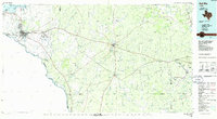
 2022 Del Rio NW2022 Print · USGSThe northern edge of Del Rio meets the rugged shoreline of the Amistad National Recreation Area in this recent survey. Local historians can trace the development of Lake View and find western-themed landmarks like Butch Cassidy Trl and Cantu Spring.
End of results
Showing maps 1-10 of 10
Top cities near Lake View
Frequently asked questions
- What are the different types of historical maps available for Lake View?
- What is the oldest map of Lake View?
- Where can I purchase historical maps of Lake View for my home or office?
- Where can I download high-res historical maps of Lake View?
- Are there historical topographic maps available for Lake View?
- Is there historical aerial imagery available for Lake View?
- Where are historical maps of Lake View sourced from?