1960s Maps of Van Zandt County, Texas
Explore 10 historic maps of Van Zandt County from the 1960s. These maps offer a rare glimpse into what life looked like during the 1960s — showing old roads, neighborhoods, homes, and landmarks that have changed or disappeared over time.
Whether you're researching your family's past, planning a metal detecting trip, or studying how Van Zandt County's landscape evolved across the 1960s, these high-resolution maps are a powerful tool for exploring the history of this region.
- Focus on a specific era: All maps on this page are from the 1960s, giving you a focused view of this time period.
- See what’s changed: Compare century-old streets, trails, and buildings to today's modern landscape using overlays and satellite layers.
- Research with precision: Use these maps for genealogy, historical research, land use analysis, or educational projects.
- View, download, or print: Maps are fully viewable online in high resolution, and can be downloaded or printed for your own records.
Start exploring Van Zandt County's history through authentic maps from the 1960s. This is your window into the past.
Van Zandt County, TX maps
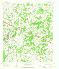
(10)- 1960 Map of Mabank, 1961 Print
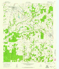 1960 Mabank1961 Print · USGSThe crossroads of Henderson, Kaufman, and Van Zandt counties are captured here in the early sixties, showing a landscape defined by small-town life and the railroad. Genealogists can trace family roots through landmarks like Elam Grove Ch, Mabank Cem, and rural outposts such as Payne Springs.5 unique versions available
 - 1962 Map of Myrtle Springs, 1965 Print
 1962 Myrtle Springs1965 Print · USGSVan Zandt County is captured in the early sixties as rural farmsteads and creek-side communities began to interface with new infrastructure. Genealogists can trace family footprints near Wesley Chapel Cemetery, the Myrtle Springs settlement, and High Cem.3 unique versions available
 - 1962 Map of Prairieville, 1965 Print
 1962 Prairieville1965 Print · USGSThe Van Zandt County countryside comes into focus in the early sixties, showing the rural crossroads and creek-fed farms of the Texas interior. Trace family landmarks like the Aanonsen Cem, Fourmile Ch, and the small settlement at Prairieville.2 unique versions available
 - 1962 Map of Cedarvale, 1965 Print
 1962 Cedarvale1965 Print · USGSVan Zandt County was a landscape of small farming communities and emerging oil fields in the early sixties. Researchers can trace family sites near North Bouie Ch, the Fairview Community Center, and the Fair Oil Field.2 unique versions available
 - 1962 Map of Wills Point, 1965 Print
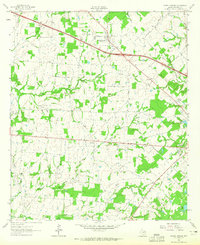
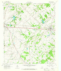
 1962 Wills Point1965 Print · USGSWills Point and the surrounding Van Zandt County countryside are shown here in the early 1960s, centered on the Texas and Pacific rail line. Genealogists can trace family landmarks like Union Grove Cem, Allen Cem, and the small settlement of Hiram.2 unique versions available
 - 1962 Map of Canton, 1965 Print
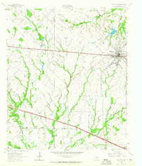
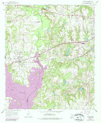
 1962 Canton1965 Print · USGSCanton and its surrounding Van Zandt County ranchlands are captured here during the early sixties, showing a landscape defined by oil fields and rural parish life. Researchers can locate family landmarks like Hillcrest Cem, Morse Chapel Cem, and several country schools including New Hope Sch.3 unique versions available
 - 1962 Map of Edgewood, 1966 Print
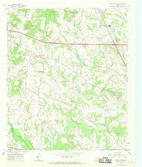
 1962 Edgewood1966 Print · USGSThe rail-corridor towns of Van Zandt County appear here in the early sixties, caught between their agricultural roots and modern infrastructure. Genealogists can locate several rural landmarks and burial sites, including White Rose Cem, Rock Hill Cem, and Rainey's Chapel.2 unique versions available
 - 1962 Map of Fruitvale, 1966 Print
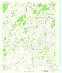
 1962 Fruitvale1966 Print · USGSVan Zandt County was a landscape of rail-side towns and petroleum exploration in the early sixties. Researchers can trace the legacy of family settlements and rural congregations at Fruitvale, Tooms Cem, and the Fruitvale Oil Field.
 - 1966 Map of Chandler, 1967 Print
 1966 Chandler1967 Print · USGSChandler and the surrounding East Texas countryside are shown in the mid-sixties during the development of Lake Palestine. Researchers can trace old family roots at Macedonia Cem and Sevenleague Cem or locate former community centers like Dixie Sch.3 unique versions available
 - 1966 Map of Mount Sylvan, 1969 Print
 1966 Mount Sylvan1969 Print · USGSThe rural communities of Smith County are frozen in the mid-sixties, showing a landscape of oil wells, creek-fed farms, and country churches. Genealogists can trace family landmarks like Sitton Cem, Dixie Sch, and the settlements of Mount Sylvan and New Harmony.2 unique versions available
End of results
Showing maps 1-10 of 10
Top cities of Van Zandt County
- Wills Point historical maps
- Canton historical maps
- Canton historical maps
- Grand Saline historical maps
- Van historical maps
- Edgewood historical maps
See more
Frequently asked questions
- What are the different types of historical maps available for Van Zandt County?
- What is the oldest map of Van Zandt County?
- Where can I purchase historical maps of Van Zandt County for my home or office?
- Where can I download high-res historical maps of Van Zandt County?
- Are there historical topographic maps available for Van Zandt County?
- Is there historical aerial imagery available for Van Zandt County?
- Where are historical maps of Van Zandt County sourced from?