Old Maps of Prairie View, Texas
Explore 12 old maps of Prairie View, spanning from 1920 to today. These high-resolution historic maps reveal how streets, neighborhoods, landmarks, and natural features evolved over time — perfect for genealogy, metal detecting, research, and local history exploration.
What you can do with these maps:
- See how Prairie View changed over time: Compare historical maps to modern-day views to trace roads, homesites, rail lines & more.
- View detailed metadata: Each map includes creators, publishers, year, scale, and archive source.
- Overlay maps with satellite & LiDAR: Visualize the past alongside modern tools to explore terrain & human change.
- Trusted historical sources: Maps sourced from the USGS, Library of Congress, and other archives.
- Access maps your way: View online, download high-res files, or order prints for personal or research use.
Start exploring old maps of Prairie View to uncover forgotten places, hidden landmarks, and the deep history beneath your feet.
Prairie View, TX maps
(12)- 1920 Map of Waller
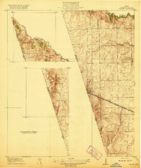 1920 Waller1920 Print · USGSThe Waller and Harris county line area comes into focus in this 1920s-era survey, detailing the early rail-and-road network. Genealogists and local historians can trace family sites like Badke Ranch, the Binford School, and the early layout of Waller.2 unique versions available
 - 1954 Map of Beaumont, 1964 Print
 1954 Beaumont1964 Print · USGSSoutheast Texas in the mid-fifties reveals a landscape of massive national forests, emerging reservoirs, and a booming oil economy. Genealogists and researchers can trace rural settlements like Dallardsville and Village Mills or locate early drilling sites at Sour Lake Oil Field.3 unique versions available
 - 1954 Map of Austin, 1964 Print
 1954 Austin1964 Print · USGSCentral Texas is captured during a period of steady growth as the capital city and its neighboring farm towns began to modernize. Researchers can trace historic rail corridors like the Southern Pacific RR or locate landmarks such as Bergstrom Air Force Base and Pilot Knob.4 unique versions available
 - 1956 Map of Hempstead
 1956 Hempstead1956 Print · USGSSoutheast Texas river country comes alive in this survey of the Brazos valley at the dawn of the motorized age. Genealogists and historians can trace the foundations of local society through schools like Pauls School, post offices at Howth P.O., and the path of the Houston and Texas Central Railroad.
 - 1957 Map of Beaumont
 1957 Beaumont1957 Print · USGSSoutheast Texas in the mid-fifties is defined by the timber-rich lands between the Trinity River and Beaumont. Trace the history of the Alabama and Coushatti Indian Reservation or locate early campus sites like Prairie View College.
 - 1960 Map of Waller, 1961 Print
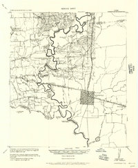
 1960 Waller1961 Print · USGSThe Waller and Prairie View area at the dawn of the 1960s reveals a landscape of growing educational institutions and vital rail corridors. Researchers can trace the boundaries of Prairie View A & M College and locate family history at Waller Cem or Mathis Cem.4 unique versions available
 - 1961 Map of Hempstead, 1963 Print
 1961 Hempstead1963 Print · USGSHempstead and the surrounding Waller County prairie are captured here in the early sixties as a center of rail commerce and petroleum production. Genealogists can locate family landmarks such as Greater Wyatt Chapel, the Brenham Cem, and the Raccoon Bend Oil Field.4 unique versions available
 - 1984 Map of Beaumont
 1984 Beaumont1984 Print · USGSSoutheast Texas in the late seventies and early eighties shows a landscape of expanding reservoirs and deep timber industry. Researchers can trace the development of the Sam Houston National Forest or locate regional landmarks like Grabbs Prairie and the Wynne State Prison Farm.3 unique versions available
 - 1985 Map of Conroe
 1985 Conroe1985 Print · USGSSoutheast Texas in the mid-eighties shows a landscape of timberlands and new lakeside developments. Researchers can trace the legacy of rail lines like the Southern Pacific RR or locate rural communities such as Plantersville, Yarboro, and Hufsmith.2 unique versions available
 - 1993 Map of Brenham
 1993 Brenham1993 Print · USGSTexas river country and the birthplace of the republic are showcased in the early nineties, centered on the confluence of the Brazos and Navasota. Researchers can trace the rail sidings of the Southern Pacific RR and locate historic community landmarks like St Paul Ch and Washington-on-the-Brazos State Park.
 - 2022 Map of Waller, 2022 Print
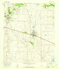
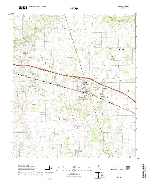 2022 Waller2022 Print · USGSThe Texas prairie west of Houston comes to life in this contemporary study of rural and university land. Genealogists can trace family roots at Saint Johns Lutheran Cem, Waller Cem, and around the historic Prairie View A and M University.
 - 2022 Map of Hempstead, 2022 Print
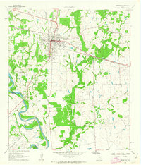
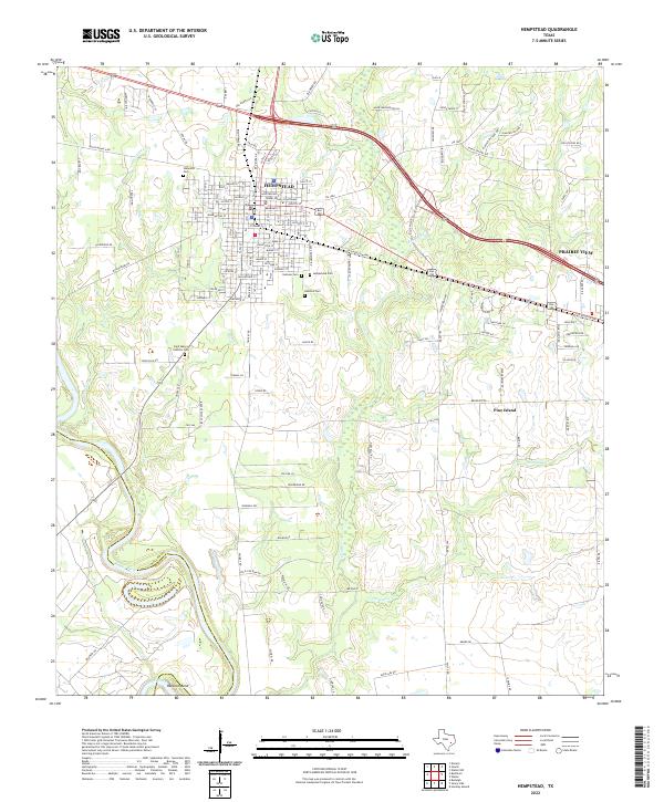 2022 Hempstead2022 Print · USGSWaller County in the twenty-first century reveals a landscape where the civic core of Hempstead meets the banks of the Brazos River. Local historians can trace family roots through numerous sites like Oakwood Cem or locate landmarks such as the Waller County Courthouse.
End of results
Showing maps 1-12 of 12
Top cities near Prairie View
- Houston historical maps
- Hempstead historical maps
- Waller historical maps
- Magnolia historical maps
- Pine Island historical maps
- Todd Mission historical maps
Frequently asked questions
- What are the different types of historical maps available for Prairie View?
- What is the oldest map of Prairie View?
- Where can I purchase historical maps of Prairie View for my home or office?
- Where can I download high-res historical maps of Prairie View?
- Are there historical topographic maps available for Prairie View?
- Is there historical aerial imagery available for Prairie View?
- Where are historical maps of Prairie View sourced from?