
1920 Map of Waller
USGS Topo · Published 1920About this map
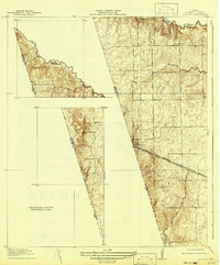
The Waller Co Harris Co Boundary Line cuts diagonally through this topography, following the winding path of Spring Creek in the north before striking a straight path south. Published just after the First World War, the map documents the rural character of the region, where family sites like Badke Ranch and the Binford School served as focal points for the local community. The terrain is notably dominated by elevations such as Hockley Mound and a point labeled as the Highest point in Harris County, providing significant landmarks in an otherwise steady coastal plain landscape. Transportation is defined by the Southern Pacific System Houston and Texas Central railroad, which parallels the Houston and Hempstead Road as they pass through the town of Waller. Large portions of the sheet remain marked as a Preliminary Edition Unsurveyed Area, indicating the ongoing nature of the geological mapping project during this era.
Find a feature on this map
14 named features on this map. Tap any name to fly to it.
Don’t see what you’re looking for? This feature index may not catch every label — zoom into the map to look around manually.
Map Details
Editions of this 1920 Waller Map
2 editions found
Other maps of this area

1916 · Hockley
USGS Topo · 1:24,000

1916 · Swanson
USGS Topo · 1:24,000

1919 · Swanson
USGS Topo · 1:31,680

1920 · Hockley
USGS Topo · 1:31,680

1950 · Houston
USGS Topo · 1:250,000

1953 · Seguin
USGS Topo · 1:250,000

1954 · Beaumont
USGS Topo · 1:250,000

1954 · Austin
USGS Topo · 1:250,000

1955 · Brookshire
USGS Topo · 1:62,500

1956 · Sealy
USGS Topo · 1:62,500