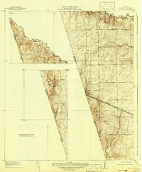
1920 Map of Waller
USGS Topo · Published 1942About this map
The Waller townsite sits at the intersection of industry and prairie on this 1916 survey, published in 1942. Located along the Waller Co Harris Co Boundary Line, the settlement is defined by the Southern Pacific System Houston and Texas Central railroad and the adjacent Houston and Texas Central Road. This transport corridor cuts a diagonal path across a landscape of subtle topographic shifts, most notably at Hockley Mound and the designated Highest point in Harris County.
Find a feature on this map
11 named features on this map. Tap any name to fly to it.
Don’t see what you’re looking for? This feature index may not catch every label — zoom into the map to look around manually.
Map Details
Editions of this 1920 Waller Map
2 editions found
Other maps of this area

1916 · Hockley
USGS Topo · 1:24,000

1916 · Swanson
USGS Topo · 1:24,000

1919 · Swanson
USGS Topo · 1:31,680

1920 · Hockley
USGS Topo · 1:31,680

1920 · Waller
USGS Topo · 1:31,680

1950 · Houston
USGS Topo · 1:250,000

1953 · Seguin
USGS Topo · 1:250,000

1954 · Beaumont
USGS Topo · 1:250,000

1954 · Austin
USGS Topo · 1:250,000

1955 · Brookshire
USGS Topo · 1:62,500