Old Maps of Orvil, Laredo for Metal Detecting
Plan your next treasure hunt with 9 historic maps of Orvil. Find old homesites, ghost towns, trails, and gathering spots that may be lost to time — perfect for identifying promising metal detecting locations.
- Locate forgotten sites: Uncover places like long-lost settlements, abandoned rail lines, or gathering spots.
- Plan better hunts: Use map overlays combined with LiDAR or satellite views to narrow in on historically rich areas.
- Made for detectorists: Thousands of hobbyists use these maps to discover relics, coins, and hidden history.
Use these historic maps to boost your research and find new opportunities beneath the surface of Orvil.
Orvil, Laredo maps
(9)- 1956 Map of Laredo East
 1956 Laredo East1956 Print · USGSEastern Webb County is documented here as a vast network of cattle ranches and rail sidings during the mid-twentieth century. Family researchers can locate legacy holdings like the Pool Ranch and L.R. Ortiz Ranch, or trace the Texas Mexican Railway past Milo Siding.
 - 1956 Map of Laredo, 1960 Print
 1956 Laredo1960 Print · USGSSouth Texas in the mid-fifties reveals a landscape shaped by border commerce, military aviation, and a booming oil industry. Trace the historic Texas and Mexican RR line through Hebbronville or locate the sprawling Mirando City Oil Field and Laredo AFB.3 unique versions available
 - 1965 Map of Orvil, 1967 Print
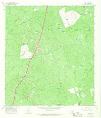 1965 Orvil1967 Print · USGSWebb County ranch lands in the mid-sixties are defined here by the intersection of traditional cattle infrastructure and modern industry. Researchers can trace the Missouri Pacific rail line through Orvil or locate the sprawling Tire Proving Ground.3 unique versions available
 - 1985 Map of Laredo
 1985 Laredo1985 Print · USGSThe Rio Grande border and the expanding city of Laredo are captured in the mid-eighties as a major international transit hub. Trace the development of Del Mar, the routes of the Texas Mexican railroad, and outlying settlements like Islitas and Las Tiendas.3 unique versions available
 - 2010 Map of Orvil, 2010 Print
 2010 Orvil2010 Print · USGSCovers Orvil, including Laredo, Webb County, and other nearby areas
 - 2013 Map of Orvil, 2013 Print
 2013 Orvil2013 Print · USGSCovers Orvil, including Laredo, Webb County, and other nearby areas
 - 2016 Map of Orvil, 2016 Print
 2016 Orvil2016 Print · USGSCovers Orvil, including Laredo, Webb County, and other nearby areas
 - 2019 Map of Orvil, 2019 Print
 2019 Orvil2019 Print · USGSCovers Orvil, including Laredo, Webb County, and other nearby areas
 - 2022 Map of Orvil, 2022 Print
 2022 Orvil2022 Print · USGSThe northern reaches of the Laredo corridor and the settlement of Orvil are documented in this recent survey of the Webb County brushland. Researchers can trace the intersection of modern logistics at Killam Industrial Blvd with traditional water tanks like La Presa Grande and Tortuga Tank.
End of results
Showing maps 1-9 of 9
Top cities near Orvil
Frequently asked questions
- What are the different types of historical maps available for Orvil?
- What is the oldest map of Orvil?
- Where can I purchase historical maps of Orvil for my home or office?
- Where can I download high-res historical maps of Orvil?
- Are there historical topographic maps available for Orvil?
- Is there historical aerial imagery available for Orvil?
- Where are historical maps of Orvil sourced from?