1900s (20th Century) Maps of Shamrock, Texas
Explore 5 historic maps of Shamrock from the 1900s (20th Century). These maps offer a rare glimpse into what life looked like during the 1900s — showing old roads, neighborhoods, homes, and landmarks that have changed or disappeared over time.
Whether you're researching your family's past, planning a metal detecting trip, or studying how Shamrock's landscape evolved across the 1900s, these high-resolution maps are a powerful tool for exploring the history of this region.
- Focus on a specific era: All maps on this page are from the 1900s, giving you a focused view of this time period.
- See what’s changed: Compare century-old streets, trails, and buildings to today's modern landscape using overlays and satellite layers.
- Research with precision: Use these maps for genealogy, historical research, land use analysis, or educational projects.
- View, download, or print: Maps are fully viewable online in high resolution, and can be downloaded or printed for your own records.
Start exploring Shamrock's history through authentic maps from the 1900s. This is your window into the past.
Shamrock, TX maps
(5)- 1954 Map of Amarillo, 1966 Print
 1954 Amarillo1966 Print · USGSThe Texas Panhandle in the mid-1960s shows a landscape of rising industrial power and deep-rooted ranching tradition. Local historians can trace the paths of the Panhandle and Santa Fe railroad or locate sites like the Pantex Ordnance Plant and Mobeetie.2 unique versions available
 - 1958 Map of Amarillo
 1958 Amarillo1958 Print · USGSThe Texas Panhandle in the mid-1950s reveals a landscape of expanding military installations and oil-rich rail towns. Local historians can trace the development of Amarillo Air Force Base or locate smaller settlements like Magic City and New Mobeetie.
 - 1963 Map of Shamrock East, 1967 Print
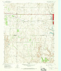
 1963 Shamrock East1967 Print · USGSShamrock and the northern Panhandle are captured here in the early sixties as the oil economy and rail lines defined local life. Genealogists can trace local landmarks like Bethel Ch, the town Cemetery, and the Chicago Rock Island and Pacific railroad.2 unique versions available
 - 1963 Map of Shamrock West, 1967 Print
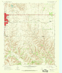
 1963 Shamrock West1967 Print · USGSThe Texas Panhandle comes into focus in the 1960s as a vital junction of the Fort Worth and Denver and Chicago Rock Island and Pacific railroads. Researchers can trace the layout of Shamrock and rural landmarks like Lela, Lone Mound Ch, and the local Rodeo Grounds.2 unique versions available
 - 1983 Map of Shamrock
 1983 Shamrock1983 Print · USGSThe Texas Panhandle in the early 1980s reveals a landscape shaped by petroleum and the rail lines of the southern plains. Genealogists and historians can trace the Chicago Rock Island and Pacific corridor through Mc Lean and Shamrock, or locate smaller centers like Magic City and Lefors.
End of results
Showing maps 1-5 of 5
Top cities near Shamrock
Frequently asked questions
- What are the different types of historical maps available for Shamrock?
- What is the oldest map of Shamrock?
- Where can I purchase historical maps of Shamrock for my home or office?
- Where can I download high-res historical maps of Shamrock?
- Are there historical topographic maps available for Shamrock?
- Is there historical aerial imagery available for Shamrock?
- Where are historical maps of Shamrock sourced from?