1960s Maps of Cedar Park, Texas
Explore 3 historic maps of Cedar Park from the 1960s. These maps offer a rare glimpse into what life looked like during the 1960s — showing old roads, neighborhoods, homes, and landmarks that have changed or disappeared over time.
Whether you're researching your family's past, planning a metal detecting trip, or studying how Cedar Park's landscape evolved across the 1960s, these high-resolution maps are a powerful tool for exploring the history of this region.
- Focus on a specific era: All maps on this page are from the 1960s, giving you a focused view of this time period.
- See what’s changed: Compare century-old streets, trails, and buildings to today's modern landscape using overlays and satellite layers.
- Research with precision: Use these maps for genealogy, historical research, land use analysis, or educational projects.
- View, download, or print: Maps are fully viewable online in high resolution, and can be downloaded or printed for your own records.
Start exploring Cedar Park's history through authentic maps from the 1960s. This is your window into the past.
Cedar Park, TX maps
(3)- 1962 Map of Leander, 1966 Print
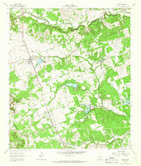 1962 Leander1966 Print · USGSCentral Texas settlements and Hill Country ranch land thrive along the rail line during the early sixties. Genealogists can trace family names at Bagdad Cem and White Stone, or locate the Independent Sch near the Southern Pacific tracks.4 unique versions available
 - 1962 Map of Nameless, 1966 Print
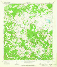 1962 Nameless1966 Print · USGSThe rural Texas Hill Country comes to life in the 1960s, showing the intersection of Travis and Williamson counties. Genealogists can locate family landmarks like Miller Cem, the small settlement of Nameless, and the sprawling Post Oak Ridge.2 unique versions available
 - 1968 Map of Jollyville, 1971 Print
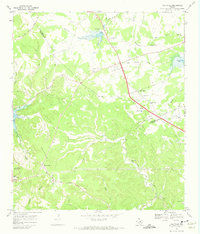 1968 Jollyville1971 Print · USGSNorth of Austin in the late sixties, the landscape was beginning to shift from rural crossroads to suburban centers. Trace the foundations of Jollyville and Pecan Park alongside historic sites like Pond Springs Cem and the Oak Grove Ch.3 unique versions available
End of results
Showing maps 1-3 of 3
Top cities near Cedar Park
- Austin historical maps
- Round Rock historical maps
- Georgetown historical maps
- Pflugerville historical maps
- Leander historical maps
- Lakeway historical maps
See more
Frequently asked questions
- What are the different types of historical maps available for Cedar Park?
- What is the oldest map of Cedar Park?
- Where can I purchase historical maps of Cedar Park for my home or office?
- Where can I download high-res historical maps of Cedar Park?
- Are there historical topographic maps available for Cedar Park?
- Is there historical aerial imagery available for Cedar Park?
- Where are historical maps of Cedar Park sourced from?