1960s Maps of Mineola, Texas
Explore 2 historic maps of Mineola from the 1960s. These maps offer a rare glimpse into what life looked like during the 1960s — showing old roads, neighborhoods, homes, and landmarks that have changed or disappeared over time.
Whether you're researching your family's past, planning a metal detecting trip, or studying how Mineola's landscape evolved across the 1960s, these high-resolution maps are a powerful tool for exploring the history of this region.
- Focus on a specific era: All maps on this page are from the 1960s, giving you a focused view of this time period.
- See what’s changed: Compare century-old streets, trails, and buildings to today's modern landscape using overlays and satellite layers.
- Research with precision: Use these maps for genealogy, historical research, land use analysis, or educational projects.
- View, download, or print: Maps are fully viewable online in high resolution, and can be downloaded or printed for your own records.
Start exploring Mineola's history through authentic maps from the 1960s. This is your window into the past.
Mineola, TX maps
(2)- 1960 Map of Lindale, 1962 Print
 1960 Lindale1962 Print · USGSLindale and its East Texas surroundings are captured here at a moment of mid-century growth along the Missouri Pacific rail line. Genealogists and local historians can trace family roots through sites like Flewellen Cem, the Bragg Morris High Sch, and the community at Friendship.3 unique versions available
 - 1960 Map of Mineola, 1962 Print
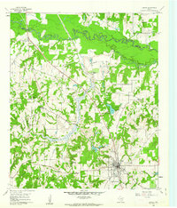
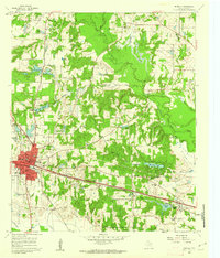 1960 Mineola1962 Print · USGSMineola sits at a critical rail junction in East Texas at the dawn of the 1960s, serving as a hub for the Texas and Pacific and Missouri Pacific. Researchers can trace rural community roots through New Hope Sch, the Mineola Paul Oil Field, and Rose Hill Ch.2 unique versions available
End of results
Showing maps 1-2 of 2
Top cities near Mineola
- Tyler historical maps
- Lindale historical maps
- Grand Saline historical maps
- Hideaway historical maps
- Van historical maps
- Quitman historical maps
See more
Top neighborhoods of Mineola
Frequently asked questions
- What are the different types of historical maps available for Mineola?
- What is the oldest map of Mineola?
- Where can I purchase historical maps of Mineola for my home or office?
- Where can I download high-res historical maps of Mineola?
- Are there historical topographic maps available for Mineola?
- Is there historical aerial imagery available for Mineola?
- Where are historical maps of Mineola sourced from?