1950s Maps of Cache County, Utah
Explore 10 historic maps of Cache County from the 1950s. These maps offer a rare glimpse into what life looked like during the 1950s — showing old roads, neighborhoods, homes, and landmarks that have changed or disappeared over time.
Whether you're researching your family's past, planning a metal detecting trip, or studying how Cache County's landscape evolved across the 1950s, these high-resolution maps are a powerful tool for exploring the history of this region.
- Focus on a specific era: All maps on this page are from the 1950s, giving you a focused view of this time period.
- See what’s changed: Compare century-old streets, trails, and buildings to today's modern landscape using overlays and satellite layers.
- Research with precision: Use these maps for genealogy, historical research, land use analysis, or educational projects.
- View, download, or print: Maps are fully viewable online in high resolution, and can be downloaded or printed for your own records.
Start exploring Cache County's history through authentic maps from the 1950s. This is your window into the past.
Cache County, UT maps
(10)- 1954 Map of Ogden, 1967 Print
 1954 Ogden1967 Print · USGSThe northern Utah corridor and Wyoming borderlands are captured here in the mid-1950s, showing the region's transition from mountain wilderness to settled valleys. Researchers can trace historic institutions like Utah State University or locate vanished points like Church Butte Station and the Trappist Monastery.3 unique versions available
 - 1954 Map of Brigham City, 1968 Print
 1954 Brigham City1968 Print · USGSNorthern Utah and the edges of the Great Salt Lake are captured here during the mid-fifties, showing the region's transition from pioneer rail hubs to modern military ranges. Researchers can find old sidings like Lemay Siding, the Golden Spike Monument, and settlements like Washakie.4 unique versions available
 - 1955 Map of Paradise, 1956 Print
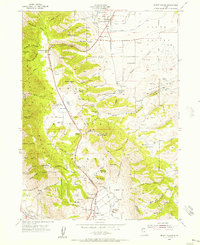
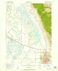
 1955 Paradise1956 Print · USGSSouthern Cache Valley thrives as a pastoral hub during the mid-fifties, centered on the gridded settlements of Paradise and Avon. Genealogists and researchers can trace family-named landmarks like McMurdie Hollow or locate historical sites including the local Cemetery and the Trout Farm along the Little Bear River.3 unique versions available
 - 1955 Map of Mantua, 1956 Print
 1955 Mantua1956 Print · USGSThe mountain town of Mantua and the surrounding national forest are captured here in the mid-1950s. Genealogists and researchers can locate the Mantua Cemetery, trace mining sites like the Holton Mine, and find youth camps such as Camp Utaba.4 unique versions available
 - 1955 Map of Huntsville, 1956 Print
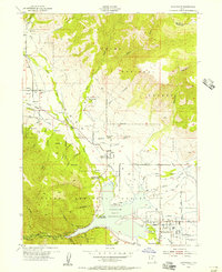 1955 Huntsville1956 Print · USGSHuntsville and the Ogden Valley are shown in the mid-fifties just as the region's river-fed agriculture began to blend with new lakeside recreation. Genealogists and local historians can trace family plots at Mountain View Cemetery or locate early industrial sites like Shanghai Creek No 1 Mine and Patio Springs.4 unique versions available
 - 1955 Map of James Peak, 1956 Print
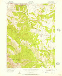
 1955 James Peak1956 Print · USGSThe high wilderness of the Cache National Forest is documented here in the mid-fifties, showing a landscape defined by canyons and peaks. Researchers can locate remote sites like the Honey Bee Mine, Fourmile Ranch, and the Davenport Jeep Trail.4 unique versions available
 - 1955 Map of Mount Pisgah, 1956 Print
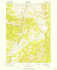
 1955 Mount Pisgah1956 Print · USGSThe high passes of the Wellsville Mountains and the valley settlements of Wellsville and Mantua are captured here in the mid-1950s. Genealogists and local historians can trace family plots at Mount Sterling Cemetery or locate old landmarks like Babbit Shanty Hill and Gold Mine Hill.4 unique versions available
 - 1955 Map of Brigham City, 1957 Print
 1955 Brigham City1957 Print · USGSBrigham City and the surrounding Box Elder valley are captured in the mid-fifties during a period of steady civic growth. Genealogists and historians can trace neighborhood developments around Lincoln School or follow the old Union Pacific lines out to Corinne and the Baker Mine.2 unique versions available
 - 1958 Map of Ogden
 1958 Ogden1958 Print · USGSNorthern Utah and southwestern Wyoming are captured here during a period of steady growth and military expansion. You can trace the Union Pacific rail lines and early road networks connecting Ogden and Logan to Bear Lake and Evanston.
 - 1958 Map of Brigham City
 1958 Brigham City1958 Print · USGSNorthern Utah in the late fifties shows a landscape of extremes, from the salt flats to the bustling Bear River Valley. Trace historical routes like the Old Immigrant Trail and locate local landmarks such as the Brigham Sugar Mill and Booth Valley School.
End of results
Showing maps 1-10 of 10
Top cities of Cache County
- Logan historical maps
- Hyrum historical maps
- North Logan historical maps
- Smithfield historical maps
- Providence historical maps
- Wellsville historical maps
See more
Frequently asked questions
- What are the different types of historical maps available for Cache County?
- What is the oldest map of Cache County?
- Where can I purchase historical maps of Cache County for my home or office?
- Where can I download high-res historical maps of Cache County?
- Are there historical topographic maps available for Cache County?
- Is there historical aerial imagery available for Cache County?
- Where are historical maps of Cache County sourced from?