1900s (20th Century) Maps of East Carbon, Utah
Explore 9 historic maps of East Carbon from the 1900s (20th Century). These maps offer a rare glimpse into what life looked like during the 1900s — showing old roads, neighborhoods, homes, and landmarks that have changed or disappeared over time.
Whether you're researching your family's past, planning a metal detecting trip, or studying how East Carbon's landscape evolved across the 1900s, these high-resolution maps are a powerful tool for exploring the history of this region.
- Focus on a specific era: All maps on this page are from the 1900s, giving you a focused view of this time period.
- See what’s changed: Compare century-old streets, trails, and buildings to today's modern landscape using overlays and satellite layers.
- Research with precision: Use these maps for genealogy, historical research, land use analysis, or educational projects.
- View, download, or print: Maps are fully viewable online in high resolution, and can be downloaded or printed for your own records.
Start exploring East Carbon's history through authentic maps from the 1900s. This is your window into the past.
East Carbon, UT maps
(9)- 1915 Map of Sunnyside
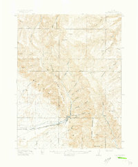 1915 Sunnyside1915 Print · USGSCarbon County’s industrial and ranching roots are laid bare in this early twentieth-century survey of the rugged Book Cliffs. Researchers can trace the Denver and Rio Grande Western rail lines serving Sunnyside or locate family landmarks like Pierson Ranch and the PUMPING STATION.4 unique versions available
 - 1915 Map of Wellington
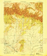 1915 Wellington1915 Print · USGSCarbon County ranching and railroading are captured here just before the First World War, as early settlements followed the canyons. You can trace family-named outposts like Youngs Ranch and Edwards Ranch or follow the path of the Sunnyside Branch railroad.3 unique versions available
 - 1956 Map of Price, 1968 Print
 1956 Price1968 Print · USGSCentral Utah in the mid-fifties showcases a landscape shaped by coal mining and mountain-fed irrigation. Trace the rail-and-river economy through the Geneva Coal Mine, the Union Pacific line, and settlements like Price and Ephraim.3 unique versions available
 - 1960 Map of Price
 1960 Price1960 Print · USGSCentral Utah in the late fifties was a landscape of coal-hauling railroads and high plateau settlements. Genealogists and local historians can trace the rail-to-river economy from Price to the mountain mining camps of Hiawatha, Dragerton, and Sunnyside.2 unique versions available
 - 1962 Map of Price
 1962 Price1962 Print · USGSCentral Utah during the early sixties shows a landscape balancing high-mountain forestry with valley agriculture and coal mining. Genealogists and historians can trace the Denver and Rio Grande Western rail lines through industrial hubs like Price or locate formerly active sites like Coal City (abandoned).
 - 1972 Map of Sunnyside, 1976 Print
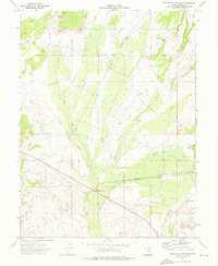
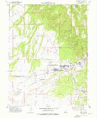 1972 Sunnyside1976 Print · USGSThe coal-mining corridor of eastern Utah is shown here in the early 1970s as a thriving industrial landscape. Local historians can trace the rail connections at Columbia Junction or locate family sites near Coke Ovens, the Cem, and East Carbon City.2 unique versions available
 - 1972 Map of Patmos Head, 1976 Print
 1972 Patmos Head1976 Print · USGSThe mining and ranching country of Carbon County comes into focus in the early 1970s. Local researchers can trace industrial sites like the Sunnyside Mine or find seasonal landmarks such as the North Willow Spring Cow Camp.2 unique versions available
 - 1972 Map of Sunnyside Junction, 1976 Print
 1972 Sunnyside Junction1976 Print · USGSCarbon County in the early seventies shows a landscape where industrial infrastructure meets ranching tradition. Trace the old Denver and Rio Grande Western rail line near Sunnyside Junction or find family landmarks like Big Spring Ranch.
 - 1980 Map of Price, 1987 Print
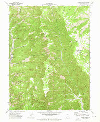
 1980 Price1987 Print · USGSCarbon County in the early 1980s is defined by its deep canyons and intensive coal operations. Researchers can trace the rail spurs and mining works of the Denver and Rio Grande Western Railroad that connect Price, Helper, and the Sunnyside Mine.3 unique versions available
End of results
Showing maps 1-9 of 9
Top neighborhoods of East Carbon
- Columbia Junction historical maps
- Sunnydale historical maps
- Columbia historical maps
- Dragerton historical maps
- Sunnyside historical maps
Frequently asked questions
- What are the different types of historical maps available for East Carbon?
- What is the oldest map of East Carbon?
- Where can I purchase historical maps of East Carbon for my home or office?
- Where can I download high-res historical maps of East Carbon?
- Are there historical topographic maps available for East Carbon?
- Is there historical aerial imagery available for East Carbon?
- Where are historical maps of East Carbon sourced from?