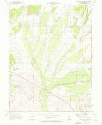
1972 Map of Sunnyside Junction
USGS Topo · Published 1976About this map
Clark Valley is the central topographical focus of this 1970s survey, where the arid landscape is defined by a network of seasonal drainages. Water courses like Pace Creek, Dugout Creek, Rock Creek, and Bear Creek converge as they flow toward the south, while Grassy Trail Creek cuts across the lower terrain. This area represents a critical intersection of transportation and resource extraction in Carbon County. The Denver and Rio Grande Western railroad serves as a primary corridor through the valley, passing near the small settlement of Sunnyside Junction. Evidence of local industry and ranching is scattered throughout the quadrangle, from the Big Spring Ranch and several Gravel Pits to a series of Jeep Trails that navigate the high ground. A small Cem and isolated Gas Wells indicate the sparse but steady human footprint in this high-desert environment.
Find a feature on this map
17 named features on this map. Tap any name to fly to it.
Don’t see what you’re looking for? This feature index may not catch every label — zoom into the map to look around manually.
Map Details
Editions of this 1972 Sunnyside Junction Map
This is the sole edition of this map. No revisions or reprints were ever made.
Other maps of this area

1886 · Price River
USGS Topo · 1:250,000

1896 · Price River
USGS Topo · 1:250,000

1915 · Sunnyside
USGS Topo · 1:62,500

1915 · Wellington
USGS Topo · 1:62,500

1948 · Woodside
USGS Topo · 1:62,500

1949 · Woodside
USGS Topo · 1:62,500

1950 · Woodside
USGS Topo · 1:62,500

1956 · Price
USGS Topo · 1:250,000

1960 · Price
USGS Topo · 1:250,000

1962 · Price
USGS Topo · 1:250,000