
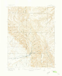
1948 Map of Woodside
USGS Topo · Published 1960About this map
Woodside sits at the base of a dramatic geological divide where the high plateaus meet the river valley in this 1948 survey. The settlement is a vital stop for the Denver and Rio Grande Western railroad, featuring a Po and Cem that speak to the small community's permanence during the mid-century. To the north, industrial activity is centered around the Geneva Coal Mine at the mouth of Horse Canyon, illustrating the era's reliance on the region's mineral wealth. The landscape is defined by the winding course of the Price River, which carves through a series of washes like Humbug Wash and Summerville Wash. Ranching life is evidenced by the Silvagni Ranch, while water management for this arid climate is visible through features like the Kiahtipes Reservoir and Coon Spring.
Find a feature on this map
37 named features on this map. Tap any name to fly to it.
Don’t see what you’re looking for? This feature index may not catch every label — zoom into the map to look around manually.
Map Details
Editions of this 1948 Woodside Map
This is the sole edition of this map. No revisions or reprints were ever made.
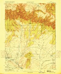
Other maps of this area

1886 · Price River
USGS Topo · 1:250,000

1896 · Price River
USGS Topo · 1:250,000
1915 · Sunnyside
USGS Topo · 1:62,500
1915 · Wellington
USGS Topo · 1:62,500

1949 · Woodside
USGS Topo · 1:62,500

1950 · Woodside
USGS Topo · 1:62,500
1954 · Flat Canyon
USGS Topo · 1:62,500
1954 · Range Creek
USGS Topo · 1:62,500

1956 · Price
USGS Topo · 1:250,000

1960 · Price
USGS Topo · 1:250,000