
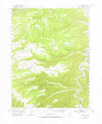
1954 Map of Flat Canyon
USGS Topo · Published 1956About this map
The Green River carves a deep path through the eastern edge of this mid-1950s survey, marking the boundary of the Uintah and Ouray Reservation. The landscape is dominated by a complex system of elevated plateaus and drainage systems, including Cottonwood Ridge, Summerhouse Ridge, and Buckskin Ridge. These high-altitude features overlook narrow waterways such as Jack Creek and Cottonwood Creek.
Find a feature on this map
37 named features on this map. Tap any name to fly to it.
Don’t see what you’re looking for? This feature index may not catch every label — zoom into the map to look around manually.
Map Details
Editions of this 1954 Flat Canyon Map
2 editions found
Other maps of this area

1885 · East Tavaputs
USGS Topo · 1:250,000

1886 · Price River
USGS Topo · 1:250,000

1896 · Price River
USGS Topo · 1:250,000

1915 · Sunnyside
USGS Topo · 1:62,500

1948 · Woodside
USGS Topo · 1:62,500

1949 · Woodside
USGS Topo · 1:62,500

1950 · Woodside
USGS Topo · 1:62,500

1953 · Nutters Hole
USGS Topo · 1:62,500

1953 · Firewater Canyon
USGS Topo · 1:62,500

1954 · Range Creek
USGS Topo · 1:62,500