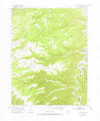
1954 Map of Flat Canyon
USGS Topo · Published 1968About this map
The Green River carves a deep boundary along the eastern edge of this territory, defining the Uintah and Ouray Indian Reservation. This 1954 survey captures a remote pocket of the Utah wilderness where life revolved around the difficult landscape of the Book Cliffs. Human activity is sparse, centered on the Rock Creek Ranch near the river and a Landing Field on the northern Flat. The terrain is characterized by a series of parallel, south-sloping finger ridges including Cottonwood Ridge, Summerhouse Ridge, and Steer Ridge, which separate deep canyons such as Rock Creek Canyon and Summerhouse Canyon. An early Gas Well on Cedar Ridge and a network of Jeep Trails suggest the beginning of resource exploration in a landscape otherwise dominated by historic ranching and tribal lands.
Find a feature on this map
42 named features on this map. Tap any name to fly to it.
Don’t see what you’re looking for? This feature index may not catch every label — zoom into the map to look around manually.
Map Details
Editions of this 1954 Flat Canyon Map
2 editions found
Other maps of this area

1885 · East Tavaputs
USGS Topo · 1:250,000

1886 · Price River
USGS Topo · 1:250,000

1896 · Price River
USGS Topo · 1:250,000

1915 · Sunnyside
USGS Topo · 1:62,500

1948 · Woodside
USGS Topo · 1:62,500

1949 · Woodside
USGS Topo · 1:62,500

1950 · Woodside
USGS Topo · 1:62,500

1953 · Nutters Hole
USGS Topo · 1:62,500

1953 · Firewater Canyon
USGS Topo · 1:62,500

1954 · Flat Canyon
USGS Topo · 1:62,500