1960s Maps of Manila, Utah
Explore 2 historic maps of Manila from the 1960s. These maps offer a rare glimpse into what life looked like during the 1960s — showing old roads, neighborhoods, homes, and landmarks that have changed or disappeared over time.
Whether you're researching your family's past, planning a metal detecting trip, or studying how Manila's landscape evolved across the 1960s, these high-resolution maps are a powerful tool for exploring the history of this region.
- Focus on a specific era: All maps on this page are from the 1960s, giving you a focused view of this time period.
- See what’s changed: Compare century-old streets, trails, and buildings to today's modern landscape using overlays and satellite layers.
- Research with precision: Use these maps for genealogy, historical research, land use analysis, or educational projects.
- View, download, or print: Maps are fully viewable online in high resolution, and can be downloaded or printed for your own records.
Start exploring Manila's history through authentic maps from the 1960s. This is your window into the past.
Manila, UT maps
(2)- 1960 Map of Vernal
 1960 Vernal1960 Print · USGSNortheastern Utah was a rugged frontier of mineral extraction and federal conservation in the mid-twentieth century. Genealogists and historians can trace the growth of Vernal, locate Gilsonite mining operations near Bonanza, and explore the 1950s boundaries of Dinosaur National Monument.
 - 1963 Map of Manila, 1964 Print
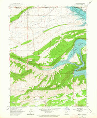 1963 Manila1964 Print · USGSThe Lucerne Valley and the rising slopes of the Uinta Mountains are captured here in the early 1960s, just as the regional landscape was being reshaped. You can trace early recreation sites like Moenkopi Campground alongside vital irrigation works such as Peoples Canal and the Canal near Manila.2 unique versions available
End of results
Showing maps 1-2 of 2
Frequently asked questions
- What are the different types of historical maps available for Manila?
- What is the oldest map of Manila?
- Where can I purchase historical maps of Manila for my home or office?
- Where can I download high-res historical maps of Manila?
- Are there historical topographic maps available for Manila?
- Is there historical aerial imagery available for Manila?
- Where are historical maps of Manila sourced from?