1900s (20th Century) Maps of Manila, Utah
Explore 8 historic maps of Manila from the 1900s (20th Century). These maps offer a rare glimpse into what life looked like during the 1900s — showing old roads, neighborhoods, homes, and landmarks that have changed or disappeared over time.
Whether you're researching your family's past, planning a metal detecting trip, or studying how Manila's landscape evolved across the 1900s, these high-resolution maps are a powerful tool for exploring the history of this region.
- Focus on a specific era: All maps on this page are from the 1900s, giving you a focused view of this time period.
- See what’s changed: Compare century-old streets, trails, and buildings to today's modern landscape using overlays and satellite layers.
- Research with precision: Use these maps for genealogy, historical research, land use analysis, or educational projects.
- View, download, or print: Maps are fully viewable online in high resolution, and can be downloaded or printed for your own records.
Start exploring Manila's history through authentic maps from the 1900s. This is your window into the past.
Manila, UT maps
(8)- 1906 Map of Marsh Peak
 1906 Marsh Peak1906 Print · USGSThe Uinta Mountains and the winding Green River corridor come alive in this survey from the early 1900s. Genealogists and historians can trace the foundations of high-country industry at Dyer Mine or locate early outposts like Dodds Cabin and Manila.2 unique versions available
 - 1908 Map of Marsh Peak
 1908 Marsh Peak1908 Print · USGSThe high Uinta wilderness along the Utah and Wyoming border is captured here during the first decade of the 1900s. Researchers can trace early industry and remote dwellings such as the Dyer Mine, Johnsons Mill, and Dodds Cabin.2 unique versions available
 - 1954 Map of Vernal, 1966 Print
 1954 Vernal1966 Print · USGSThe Green River basin and Uinta Mountains come alive in this mid-century survey of northeastern Utah and northwestern Colorado. Genealogists and researchers can trace the development of remote outposts like Little Bonanza, Artesia, and Dutch John alongside the expanding Flaming Gorge Reservoir.4 unique versions available
 - 1958 Map of Vernal
 1958 Vernal1958 Print · USGSThe Uinta Basin at the end of the fifties reveals a landscape shaped by massive river systems and burgeoning energy interests. Researchers can trace the layout of Uintah and Ouray Indian Reservation lands and industrial sites like the Gilsonite coking plant and Bonanza.
 - 1960 Map of Vernal
 1960 Vernal1960 Print · USGSNortheastern Utah was a rugged frontier of mineral extraction and federal conservation in the mid-twentieth century. Genealogists and historians can trace the growth of Vernal, locate Gilsonite mining operations near Bonanza, and explore the 1950s boundaries of Dinosaur National Monument.
 - 1963 Map of Manila, 1964 Print
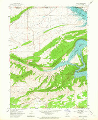 1963 Manila1964 Print · USGSThe Lucerne Valley and the rising slopes of the Uinta Mountains are captured here in the early 1960s, just as the regional landscape was being reshaped. You can trace early recreation sites like Moenkopi Campground alongside vital irrigation works such as Peoples Canal and the Canal near Manila.2 unique versions available
 - 1981 Map of Dutch John, 1982 Print
 1981 Dutch John1982 Print · USGSThe high Uinta plateau and the massive reservoir system appear here as they were in the early eighties. Local researchers can trace the roads connecting Manila and Greendale, or locate remote landmarks like the Dyer Mine and Spirit Lake.2 unique versions available
 - 1996 Map of Manila, 1999 Print
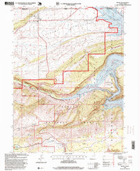 1996 Manila1999 Print · USGSNear the Wyoming border in the 1990s, the landscape around Manila reveals a rugged transition from high desert valleys to the deep canyons of the Green River. Researchers can trace recreational development along Flaming Gorge Reservoir or locate the Cem and Summit Springs Guard Station.
End of results
Showing maps 1-8 of 8
Frequently asked questions
- What are the different types of historical maps available for Manila?
- What is the oldest map of Manila?
- Where can I purchase historical maps of Manila for my home or office?
- Where can I download high-res historical maps of Manila?
- Are there historical topographic maps available for Manila?
- Is there historical aerial imagery available for Manila?
- Where are historical maps of Manila sourced from?