1970s Maps of West Point, Utah
Explore 3 historic maps of West Point from the 1970s. These maps offer a rare glimpse into what life looked like during the 1970s — showing old roads, neighborhoods, homes, and landmarks that have changed or disappeared over time.
Whether you're researching your family's past, planning a metal detecting trip, or studying how West Point's landscape evolved across the 1970s, these high-resolution maps are a powerful tool for exploring the history of this region.
- Focus on a specific era: All maps on this page are from the 1970s, giving you a focused view of this time period.
- See what’s changed: Compare century-old streets, trails, and buildings to today's modern landscape using overlays and satellite layers.
- Research with precision: Use these maps for genealogy, historical research, land use analysis, or educational projects.
- View, download, or print: Maps are fully viewable online in high resolution, and can be downloaded or printed for your own records.
Start exploring West Point's history through authentic maps from the 1970s. This is your window into the past.
West Point, UT maps
(3)- 1972 Map of Antelope Island North, 1973 Print
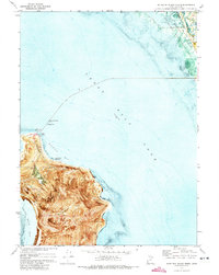 1972 Antelope Island North1973 Print · USGSAntelope Island and the surrounding waters are documented in the early seventies through this detailed orthophotomap. Genealogists and historians can trace shoreline changes and local landmarks like Ladyfinger Springs, the Great Salt Lake State Park, and Camera Flats.
 - 1972 Map of Clearfield, 1974 Print
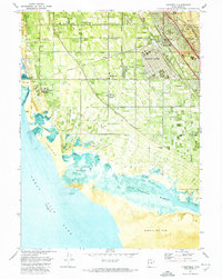 1972 Clearfield1974 Print · USGSClearfield and Syracuse are shown at a peak of military and industrial activity in the early seventies, between the Great Salt Lake and the mountains. Researchers can trace the layout of Hill Air Force Base, local landmarks like Syracuse Cem, and the massive Freeport Center rail complex.
 - 1972 Map of Ogden Bay, 1974 Print
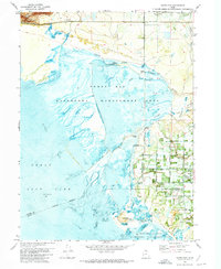 1972 Ogden Bay1974 Print · USGSThe eastern shore of the Great Salt Lake comes into focus in the early seventies, showing a landscape defined by water management and river deltas. Trace the historic Southern Pacific line past Hooper Hot Springs or locate the Hales Bend site.
End of results
Showing maps 1-3 of 3
Top cities near West Point
- Ogden historical maps
- Layton historical maps
- Bountiful historical maps
- Roy historical maps
- Kaysville historical maps
- Syracuse historical maps
See more
Frequently asked questions
- What are the different types of historical maps available for West Point?
- What is the oldest map of West Point?
- Where can I purchase historical maps of West Point for my home or office?
- Where can I download high-res historical maps of West Point?
- Are there historical topographic maps available for West Point?
- Is there historical aerial imagery available for West Point?
- Where are historical maps of West Point sourced from?