1900s (20th Century) Maps of Emery, Utah
Explore 7 historic maps of Emery from the 1900s (20th Century). These maps offer a rare glimpse into what life looked like during the 1900s — showing old roads, neighborhoods, homes, and landmarks that have changed or disappeared over time.
Whether you're researching your family's past, planning a metal detecting trip, or studying how Emery's landscape evolved across the 1900s, these high-resolution maps are a powerful tool for exploring the history of this region.
- Focus on a specific era: All maps on this page are from the 1900s, giving you a focused view of this time period.
- See what’s changed: Compare century-old streets, trails, and buildings to today's modern landscape using overlays and satellite layers.
- Research with precision: Use these maps for genealogy, historical research, land use analysis, or educational projects.
- View, download, or print: Maps are fully viewable online in high resolution, and can be downloaded or printed for your own records.
Start exploring Emery's history through authentic maps from the 1900s. This is your window into the past.
Emery, UT maps
(7)- 1925 Map of Acord Lakes
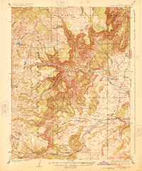 1925 Acord Lakes1925 Print · USGSThe high plateau and canyon country of Sevier and Emery Counties are captured here in the mid-1920s as ranching and early mining defined the local economy. Researchers can locate remote family landmarks like Peacocks Place, the Browning Mine, and the historic Quitchupah Ranch.3 unique versions available
 - 1956 Map of Salina
 1956 Salina1956 Print · USGSCentral Utah in the mid-fifties reveals a landscape of high plateaus and desert basins before the modern highway era. Researchers can trace the ranching and mining roots of Hanksville and Loa or locate the Lucky Strike Mine near the San Rafael Swell.5 unique versions available
 - 1960 Map of Salina
 1960 Salina1960 Print · USGSThe high plateaus and canyonlands of south-central Utah appear in the early sixties as a region of remote ranching towns and developing parklands. Researchers can trace historic settlements like Fruita and Loa or locate the uranium mines and the tracks of the Denver and Rio Grande Western RR.2 unique versions available
 - 1962 Map of Salina
 1962 Salina1962 Print · USGSSevier County and the surrounding desert wilderness appear here in the early sixties as a network of isolated river valley towns and high-altitude forests. Researchers can locate remote landmarks like Fruita, trace the Denver & Rio Grande Western RR, and find backcountry sites like the Aquarius Ranger Station.
 - 1968 Map of Emery West, 1972 Print
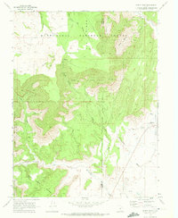 1968 Emery West1972 Print · USGSThe high desert and forest boundaries of central Utah come into focus in the late sixties, capturing the settlement of Emery and its surrounding watershed. Genealogists and researchers can locate the Emery Cem, trace the Link Canyon Mine, and follow the path of Quitchupah Creek.
 - 1968 Map of Emery East, 1972 Print
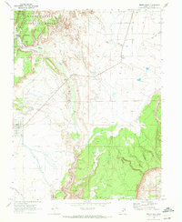 1968 Emery East1972 Print · USGSEmery and Moore are captured during the late sixties as agricultural hubs between the national forest and the desert reefs. Genealogists and historians can trace local landmarks like the Cem cemetery, the winding Muddy Creek, and industrial markers like the Gravel Pit.2 unique versions available
 - 1980 Map of Salina, 1981 Print
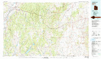 1980 Salina1981 Print · USGSCentral Utah in the late twentieth century reveals a landscape of high plateaus and transit corridors. Trace the Denver and Rio Grande Western RR past Salina or locate remote sites like Browning Mine and Fish Lake.2 unique versions available
End of results
Showing maps 1-7 of 7
Top cities near Emery
Frequently asked questions
- What are the different types of historical maps available for Emery?
- What is the oldest map of Emery?
- Where can I purchase historical maps of Emery for my home or office?
- Where can I download high-res historical maps of Emery?
- Are there historical topographic maps available for Emery?
- Is there historical aerial imagery available for Emery?
- Where are historical maps of Emery sourced from?