1980s Maps of Horse Canyon, Utah
Explore 2 historic maps of Horse Canyon from the 1980s. These maps offer a rare glimpse into what life looked like during the 1980s — showing old roads, neighborhoods, homes, and landmarks that have changed or disappeared over time.
Whether you're researching your family's past, planning a metal detecting trip, or studying how Horse Canyon's landscape evolved across the 1980s, these high-resolution maps are a powerful tool for exploring the history of this region.
- Focus on a specific era: All maps on this page are from the 1980s, giving you a focused view of this time period.
- See what’s changed: Compare century-old streets, trails, and buildings to today's modern landscape using overlays and satellite layers.
- Research with precision: Use these maps for genealogy, historical research, land use analysis, or educational projects.
- View, download, or print: Maps are fully viewable online in high resolution, and can be downloaded or printed for your own records.
Start exploring Horse Canyon's history through authentic maps from the 1980s. This is your window into the past.
Horse Canyon, UT maps
(2)- 1980 Map of Huntington, 1981 Print
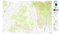 1980 Huntington1981 Print · USGSEmery and Carbon County landscapes are captured here during the early eighties, showcasing a region defined by high plateaus and mining towns. Researchers can trace the Denver and Rio Grande Western Railroad corridor and locate landmarks like the Cleveland-Lloyd Dinosaur Quarry and Hiawatha.
 - 1985 Map of Lila Point
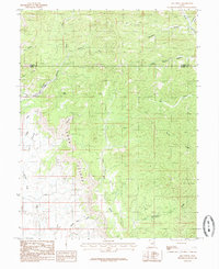 1985 Lila Point1985 Print · USGSThe Book Cliffs escarpment and Emery County desert appear here in the mid-1980s. Researchers can trace the rugged drainage systems of Horse Canyon and Lila Canyon or locate landmarks like Lila Point and Buckskin.
End of results
Showing maps 1-2 of 2
Frequently asked questions
- What are the different types of historical maps available for Horse Canyon?
- What is the oldest map of Horse Canyon?
- Where can I purchase historical maps of Horse Canyon for my home or office?
- Where can I download high-res historical maps of Horse Canyon?
- Are there historical topographic maps available for Horse Canyon?
- Is there historical aerial imagery available for Horse Canyon?
- Where are historical maps of Horse Canyon sourced from?