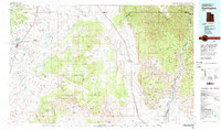
1980 Map of Huntington
USGS Topo · Published 1981About this map
The Cleveland-Lloyd Dinosaur Quarry stands as a focal point in this landscape where the geological past meets early 1980s Utah ranching and mining country. The topography is dominated by the dramatic escarpments of the Roan Cliffs and Book Cliffs, which overlook the Gunnison Valley and the Beckwith Plateau. Settlement centers like Huntington, Cleveland, and Elmo are concentrated in the west near Castle Valley, while the eastern portion of the map showcases the winding course of the Green River through Gray Canyon. The transition from the high desert terrain of the San Rafael Swell to the high cliffs is bisected by the Denver and Rio Grande Western Railroad, illustrating the vital transportation corridors that connected these isolated high-plateau communities to the broader region.
Find a feature on this map
74 named features on this map. Tap any name to fly to it.
Don’t see what you’re looking for? This feature index may not catch every label — zoom into the map to look around manually.
Map Details
Editions of this 1980 Huntington Map
This is the sole edition of this map. No revisions or reprints were ever made.
Other maps of this area

1885 · San Rafael
USGS Topo · 1:250,000

1885 · Manti
USGS Topo · 1:250,000

1885 · East Tavaputs
USGS Topo · 1:250,000

1885 · La Sal
USGS Topo · 1:250,000

1885 · Fish Lake
USGS Topo · 1:250,000

1886 · Price River
USGS Topo · 1:250,000

1895 · Manti
USGS Topo · 1:250,000

1896 · Price River
USGS Topo · 1:250,000

1896 · Fish Lake
USGS Topo · 1:250,000

1914 · Castle Gate
USGS Topo · 1:62,500