1980s Maps of Castle Valley, Utah
Explore 4 historic maps of Castle Valley from the 1980s. These maps offer a rare glimpse into what life looked like during the 1980s — showing old roads, neighborhoods, homes, and landmarks that have changed or disappeared over time.
Whether you're researching your family's past, planning a metal detecting trip, or studying how Castle Valley's landscape evolved across the 1980s, these high-resolution maps are a powerful tool for exploring the history of this region.
- Focus on a specific era: All maps on this page are from the 1980s, giving you a focused view of this time period.
- See what’s changed: Compare century-old streets, trails, and buildings to today's modern landscape using overlays and satellite layers.
- Research with precision: Use these maps for genealogy, historical research, land use analysis, or educational projects.
- View, download, or print: Maps are fully viewable online in high resolution, and can be downloaded or printed for your own records.
Start exploring Castle Valley's history through authentic maps from the 1980s. This is your window into the past.
Castle Valley, UT maps
(4)- 1983 Map of Moab
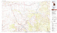 1983 Moab1983 Print · USGSThe Colorado River corridor near Moab is captured here in the early eighties, showcasing a landscape of uranium mining and iconic parklands. Trace the Denver and Rio Grande Western RR as it passes through Cisco or locate landmarks like Delicate Arch and the Telluride Mines.3 unique versions available
 - 1985 Map of Big Bend, 1986 Print
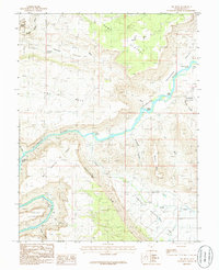 1985 Big Bend1986 Print · USGSGrand County's dramatic canyon country is mapped here in the mid-1980s as the Colorado River winds past iconic formations. Trace the river's path through Whites Rapids and Big Bend or locate landmarks like Delicate Arch and Parriott Mesa.2 unique versions available
 - 1985 Map of Rill Creek, 1986 Print
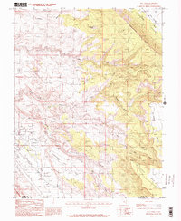 1985 Rill Creek1986 Print · USGSThe Grand County high country and canyonlands appear here in the mid-1980s, documenting a landscape of steep mesas and vital water sources. Researchers can trace remote 4WD routes across Porcupine Rim or locate local landmarks like Coffee Pot Rock and the Rodeo Ground.2 unique versions available
 - 1985 Map of Fisher Towers, 1986 Print
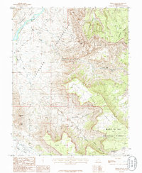 1985 Fisher Towers1986 Print · USGSGrand County’s red rock landscape is captured in the mid-1980s, documenting a labyrinth of canyons and soaring spires. Trace the vertical reaches of Fisher Towers and Titan Tower, or locate the Priest and Nuns and the Onion Creek Rapids.
End of results
Showing maps 1-4 of 4
Top cities near Castle Valley
Frequently asked questions
- What are the different types of historical maps available for Castle Valley?
- What is the oldest map of Castle Valley?
- Where can I purchase historical maps of Castle Valley for my home or office?
- Where can I download high-res historical maps of Castle Valley?
- Are there historical topographic maps available for Castle Valley?
- Is there historical aerial imagery available for Castle Valley?
- Where are historical maps of Castle Valley sourced from?