1980s Maps of Enoch, Utah
Explore 2 historic maps of Enoch from the 1980s. These maps offer a rare glimpse into what life looked like during the 1980s — showing old roads, neighborhoods, homes, and landmarks that have changed or disappeared over time.
Whether you're researching your family's past, planning a metal detecting trip, or studying how Enoch's landscape evolved across the 1980s, these high-resolution maps are a powerful tool for exploring the history of this region.
- Focus on a specific era: All maps on this page are from the 1980s, giving you a focused view of this time period.
- See what’s changed: Compare century-old streets, trails, and buildings to today's modern landscape using overlays and satellite layers.
- Research with precision: Use these maps for genealogy, historical research, land use analysis, or educational projects.
- View, download, or print: Maps are fully viewable online in high resolution, and can be downloaded or printed for your own records.
Start exploring Enoch's history through authentic maps from the 1980s. This is your window into the past.
Enoch, UT maps
(2)- 1980 Map of Panguitch, 1981 Print
 1980 Panguitch1981 Print · USGSThe high plateau country of Southern Utah is captured here in the early eighties, centered on the Sevier River and the gateway town of Panguitch. Researchers can trace the boundaries of Bryce Canyon National Park and find local landmarks like Ruby's Inn, Panguitch Lake, and Hatch.2 unique versions available
 - 1982 Map of Cedar City
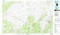 1982 Cedar City1982 Print · USGSThe high desert and mountain ranges of southern Utah are captured here in the early eighties, from the growth of the foothills to remote rail sidings. Genealogists and historians can trace the paths between Cedar City, the desert junctions of Beryl Junction, and local landmarks like Quichapa Lake.
End of results
Showing maps 1-2 of 2
Top cities near Enoch
- Cedar City historical maps
- Parowan historical maps
- Kanarraville historical maps
- Summit historical maps
- Brian Head historical maps
Frequently asked questions
- What are the different types of historical maps available for Enoch?
- What is the oldest map of Enoch?
- Where can I purchase historical maps of Enoch for my home or office?
- Where can I download high-res historical maps of Enoch?
- Are there historical topographic maps available for Enoch?
- Is there historical aerial imagery available for Enoch?
- Where are historical maps of Enoch sourced from?