1990s Maps of Eureka, Utah
Explore 2 historic maps of Eureka from the 1990s. These maps offer a rare glimpse into what life looked like during the 1990s — showing old roads, neighborhoods, homes, and landmarks that have changed or disappeared over time.
Whether you're researching your family's past, planning a metal detecting trip, or studying how Eureka's landscape evolved across the 1990s, these high-resolution maps are a powerful tool for exploring the history of this region.
- Focus on a specific era: All maps on this page are from the 1990s, giving you a focused view of this time period.
- See what’s changed: Compare century-old streets, trails, and buildings to today's modern landscape using overlays and satellite layers.
- Research with precision: Use these maps for genealogy, historical research, land use analysis, or educational projects.
- View, download, or print: Maps are fully viewable online in high resolution, and can be downloaded or printed for your own records.
Start exploring Eureka's history through authentic maps from the 1990s. This is your window into the past.
Eureka, UT maps
(2)- 1992 Map of Eureka
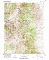 1992 Eureka1992 Print · USGSThe Tintic Mining District is shown here in the early nineties, revealing a landscape transformed by decades of hard-rock mining. Genealogists and historians can trace former town sites like Knightville and Dividend alongside major shafts including the Mammoth Shaft and Chief No 1.2 unique versions available
 - 1992 Map of Tintic Junction
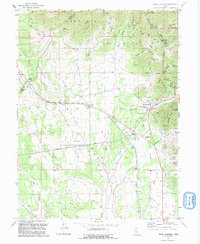 1992 Tintic Junction1992 Print · USGSThe Tintic Mining District is shown in the late twentieth century as it transitioned from an industrial powerhouse to a quieter rural landscape. Researchers can trace the heritage of local families and the ore economy through Silver City, Mammoth, and the Victoria Gold Mine.
End of results
Showing maps 1-2 of 2
Top cities near Eureka
Frequently asked questions
- What are the different types of historical maps available for Eureka?
- What is the oldest map of Eureka?
- Where can I purchase historical maps of Eureka for my home or office?
- Where can I download high-res historical maps of Eureka?
- Are there historical topographic maps available for Eureka?
- Is there historical aerial imagery available for Eureka?
- Where are historical maps of Eureka sourced from?