1960s Maps of Trout Creek, Utah
Explore 2 historic maps of Trout Creek from the 1960s. These maps offer a rare glimpse into what life looked like during the 1960s — showing old roads, neighborhoods, homes, and landmarks that have changed or disappeared over time.
Whether you're researching your family's past, planning a metal detecting trip, or studying how Trout Creek's landscape evolved across the 1960s, these high-resolution maps are a powerful tool for exploring the history of this region.
- Focus on a specific era: All maps on this page are from the 1960s, giving you a focused view of this time period.
- See what’s changed: Compare century-old streets, trails, and buildings to today's modern landscape using overlays and satellite layers.
- Research with precision: Use these maps for genealogy, historical research, land use analysis, or educational projects.
- View, download, or print: Maps are fully viewable online in high resolution, and can be downloaded or printed for your own records.
Start exploring Trout Creek's history through authentic maps from the 1960s. This is your window into the past.
Trout Creek, UT maps
(2)- 1961 Map of Trout Creek, 1963 Print
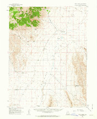 1961 Trout Creek1963 Print · USGSJuab County’s remote desert basins and mountain ranges are documented here in the early 1960s, showing a landscape shaped by scarce water and isolation. Researchers can trace the layout of Partoun and Trout Creek or locate vital desert water sources like Coyote Spring and Salt Marsh Lake.
 - 1962 Map of Delta
 1962 Delta1962 Print · USGSWest Central Utah in the early sixties reveals a landscape of desert agriculture and military testing grounds. Researchers can trace the Union Pacific line through Delta or locate historic sites like the Pony Express Monument and Silver City.
End of results
Showing maps 1-2 of 2
Frequently asked questions
- What are the different types of historical maps available for Trout Creek?
- What is the oldest map of Trout Creek?
- Where can I purchase historical maps of Trout Creek for my home or office?
- Where can I download high-res historical maps of Trout Creek?
- Are there historical topographic maps available for Trout Creek?
- Is there historical aerial imagery available for Trout Creek?
- Where are historical maps of Trout Creek sourced from?