1950s Maps of Big Water, Utah
Explore 2 historic maps of Big Water from the 1950s. These maps offer a rare glimpse into what life looked like during the 1950s — showing old roads, neighborhoods, homes, and landmarks that have changed or disappeared over time.
Whether you're researching your family's past, planning a metal detecting trip, or studying how Big Water's landscape evolved across the 1950s, these high-resolution maps are a powerful tool for exploring the history of this region.
- Focus on a specific era: All maps on this page are from the 1950s, giving you a focused view of this time period.
- See what’s changed: Compare century-old streets, trails, and buildings to today's modern landscape using overlays and satellite layers.
- Research with precision: Use these maps for genealogy, historical research, land use analysis, or educational projects.
- View, download, or print: Maps are fully viewable online in high resolution, and can be downloaded or printed for your own records.
Start exploring Big Water's history through authentic maps from the 1950s. This is your window into the past.
Big Water, UT maps
(2)- 1953 Map of Nipple Butte, 1956 Print
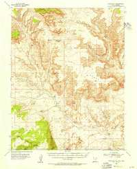 1953 Nipple Butte1956 Print · USGSThe high plateaus of the Utah-Arizona border are shown here in the early fifties, before the landscape was altered by massive downstream damming. Researchers can trace remote water sources and cattle-country landmarks like Jacobs Tanks, Alkali Seep, and the Windmill below Nipple Butte.2 unique versions available
 - 1956 Map of Escalante
 1956 Escalante1956 Print · USGSSouthern Utah and Northern Arizona are charted here in the mid-fifties, just before the canyon floor was transformed. Researchers can trace remote desert commerce at Oljeto Trading Post, find the Adairville (ruins), and locate Uranium mines.5 unique versions available
End of results
Showing maps 1-2 of 2
Top cities near Big Water
Frequently asked questions
- What are the different types of historical maps available for Big Water?
- What is the oldest map of Big Water?
- Where can I purchase historical maps of Big Water for my home or office?
- Where can I download high-res historical maps of Big Water?
- Are there historical topographic maps available for Big Water?
- Is there historical aerial imagery available for Big Water?
- Where are historical maps of Big Water sourced from?